button
Welcome to the RTMM Alaska Power Project (APP)
Natural Energy Converted to Usable Energy

Download NOTAM: All of the locations below may be downloaded and installed in the traditional manner. However, all of the locations below are built into the new RTMM express methods of installation. (See: Downloads)

RTMM presents its "Alaska Power Project" ("APP"). 

Dr. Thomas Menzel, Doug Linn and the team at RTMM have put together a new and unique set of scenic locations and enhancements all along the southeastern Alaska "Panhandle" region that will give pilots many hours of enjoyment. They created the individual facilities and aligned them with their real-world locations where possible. Then, by using objects from the RTMM libraries, they made them look as similar to their real-world designs as possible. The process continued by building dispatches and scenic flight plans, then creating tours that will take the user on various delivery and maintenance runs out and back to these beautiful and sometimes, remote, locations

Hydroelectric power generation is a cornerstone of the energy solution for Alaska and this project highlights some of those facilities involved. These scenery locations are used to continue the RTMM focus in the area and give users a great new example of RTMM's "From Here to There" approach.

So get ready to "Plug-In and Power Up" with the Alaska Power Project at Return to Misty Moorings. See a preview trailer video of APP by clicking on the image below:

Page Directory and Links

Page Directory:

wolf
donations
Chinook-Heavy Lifter


Need Heavy Lifting Capability?
Major construction projects like Hydroelectric Plants require very special heavy lifting capability. Heavy lifting is not a problem if you have the CH-47D Misty Moorings Chinook.This repaint is by Klaus Tröppner for the MilViz Boeing CH47D Chinook payware helicopter-addon for FSX.

Installation and Known Issues

TO INSTALL the ALASKA POWER PROJECT

Download NOTAM: All of the locations below may be downloaded and installed in the traditional manner. However, all of the locations below are built into the new RTMM express methods of installation. (See: Downloads) You do NOT need to download the library is you are using the RTMM Express method of addition.


Zip Button <= Click to download Latest APP.zip *** (Version 2.1 - Latest 05.25.2019) TRADITIONAL ONLY

App Library <=Click to go to Object Library Page to download the latest RTMM Medical and APP Library FSXP3D.

  • NOTAM: This object library must be downloaded and installed to see the objects in the APP if you are using the TRADITIONAL installation method. Otherwise, this is included in the consolidated downloads.. This library is used for both "Medical" and the "Alaska Power Project". (If you have the older libraries: RTMM Medical TEMP and or RTMM APP TEMP, these must be removed and replaced with this new library).
    1. Put the "Alaska Power Project" folder where you put you RTMM scenery locations ... and activate it. This may need to be re-downloaded as we make updates and corrections to APP. All locations are included in this single zip except for Whitman Lake***.
    2. Put the "RTMM APP Library TEMP" folder where you put your RTMM libraries ... and activate it. The library will not change that often, so once downloaded, you will not have to re-download unless we notify you of changes.
    3. Libraries: The RTMM Libraries should all be downloaded and installed. (See Object Library Page)
    4. APP, like the rest of RTMM depends on ORBX SAK (for the Juneau area) and PFJ (for the Ketchikan area) both of these are recommended for successfully viewing this project.

    KNOWN ISSUES

    • Helipad Landing Gear: When landing on some helipads, the landing gear (runners/wheels) will sink slightly into the surface of the helipad. We are unable to fix this problem at this time.
    • Crossing a Shoreline: When crossing a shoreline, such as at Reynolds Creek PP10, going from the lake to the pond, you must be in an amphibian with wheels down to cross the shoreline. We are unable to create a "water path" through the ORBX shoreline. Reynolds Creek is the only place where this happens in APP.
    • *** Whitman Lake PP09 - Whitman Lake, PP09 must be added separately (instructions at location below). If you have PAKT Pay ware, you cannot use Whitman Lake ... it is not compatible. For that reason, it is a separate download.
    • Magnetic Headings on Water Runways - The Magnetic Heading on the Water Runways may not have the Magnetic Deviation in them. Since is it water, it doesn't really matter.
    • Starting Point 7AK2 (Snettisham) - There was already a fine airport and starting points where the Snettisham hydro plant is located. There is no "PPxx" starting point, 7AK2 will be used.


    RTMM Alaska Power Project Maps
    SE Alaska Electricle Intertie

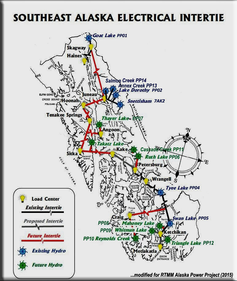
    APP as seen on Google Earth:

    Vüqar Quliyev has created an interactive Google Earth "KMZ" file that is an excellent Google Earth Logoreference for the APP Hydro plants. Download the KMZ file HERE. When you click on it, Google Earth comes up. Look in the left column for Alaska Power Project and click on the box beside it. Only checked locations will now show. Zoom in on them and LEFT click on the title and you will get the information on the plant and the information for it. If you click on the thumbnail, you'll get the enlarged picture. If you click on the map, you will get the map. The latest file has all of the hydro plants in it (as well as everything else in RTMM!)

    Quick Reference Location and Startup Information

    Name
    Latitude
    Longitude
    Mag
    Terrain
    WayPoint
    Annex Creek
    N58 19.5980
    W134 7.5200
    244
    W
    PP13
    Blue Lake
    N57 3.8380
    W135 12.0060
    181
    W
    PP16
    Cascade Creek
    N57 1.7519
    W132 44.4136
    291
    W
    PP11
    Goat Lake
    N59 31.6249
    W135 11.0503
    348
    W
    PP01
    Lake Dorothy
    N58 13.8229
    W134 3.3011
    145
    W
    PP02
    Mahoney Lake
    N55 25.1679
    W131 31.9041
    153
    W
    PP08
    Reynolds Creek
    N55 12.9880
    W132 36.4340
    314
    W
    PP10
    Ruth Lake
    N56 58.4483
    W132 47.2125
    199
    W
    PP06
    Salmon Creek
    N58 19.9230
    W134 28.3930
    341
    W
    PP14
    Snettisham
    N58 19.5980
    W134 7.5200
    245
    W
    PP03
    Swan Lake
    N55 37.0328
    W131 21.5323
    212
    W
    PP05
    Takatz Lake
    N57 8.0273
    W134 50.0131
    134
    W
    PP15
    Thayer Creek
    N57 34.7300
    W134 37.5800
    004
    W
    PP07
    Triangle Lake
    N55 12.8590
    W131 26.3430
    159
    W
    PP12
    Tyee Lake Hydro
    N56 11.9827
    W131 30.5314
    358
    W
    PP04
    Whitman Lake Hydro
    N55 19.9972
    W131° 31.9366
    277
    W
    PP09
    Back to Top
    Scenery Locations for the Alaska Power Project
    Annex Creek
    Click to Enlarge

    SeasonSwitch
    Jan Feb Mar
    Apr May Jun
    Jul Aug Sep
    Oct Nov Dec
    Legend

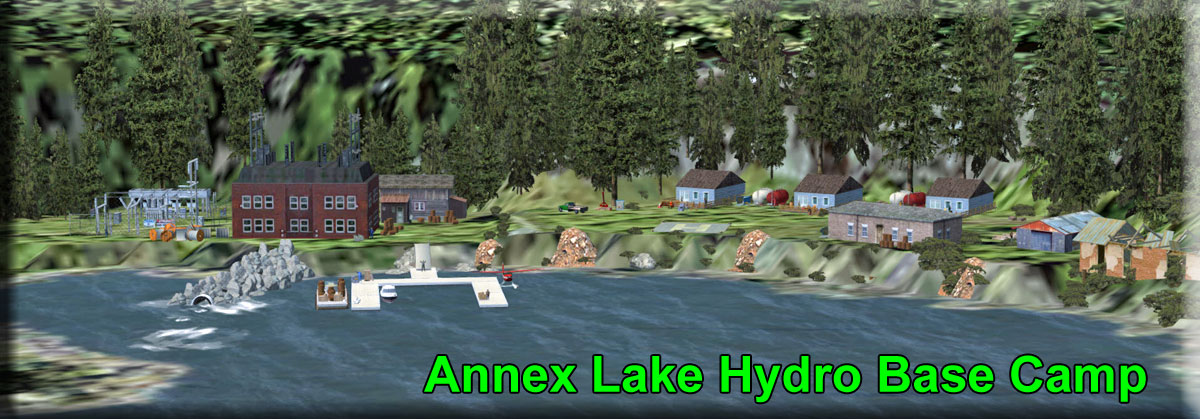
    Annex Creek Hydro Base Camp - PP13 - By Thomas Menzel
    (Refreshed V2.0-02.23.2019)

    The Annex Creek Hydroelectric Project was constructed by the Alaska Gastineau Mining Company to power their new mill at Thane.  The project came on line in 1915 and still provides clean, renewable power to Juneau today, a century later.  The Annex Creek Project is located almost entirely within the Tongass National Forest and is operated under a Special Use Permit administered by the U.S. Forest Service, Juneau Ranger District.  It is also licensed by the Federal Energy Regulatory Commission (FERC License P-2307).

    Be sure to look at the readme for excellent maps of the complex.

    Map Button Document Button how to install button

    • Start Points:
    • ...Upper Lake: N58 19.5980 ... W134 7.52000 ... 245
    • ... Main Dock: N58 19.0392 ... W134° 6.0409 ... 096
    Blue Lake
    Click to Enlarge

    SeasonSwitch
    Jan Feb Mar
    Apr May Jun
    Jul Aug Sep
    Oct Nov Dec
    Legend

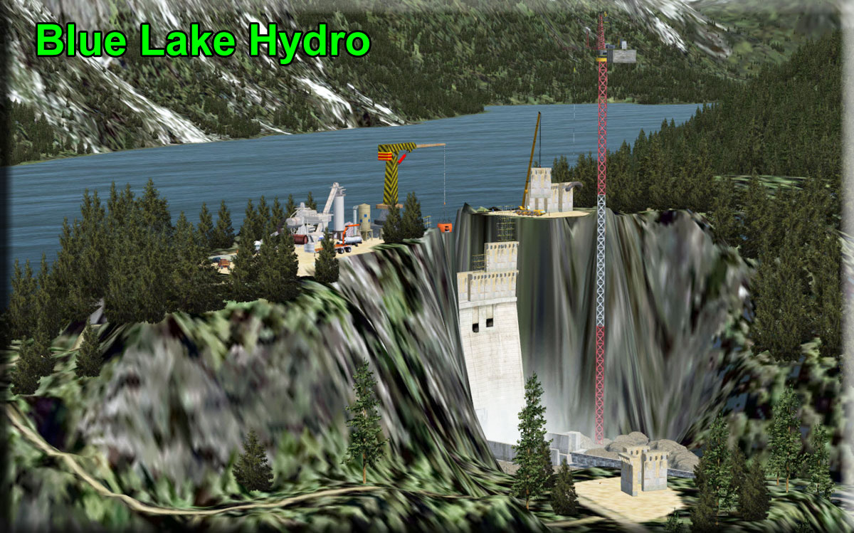
    Blue Lake Hydro Expansion Project - PP16 - By Doug Linn
    (Refreshed V2.0-02.23.2019)

    This is an existing dam on Blue Lake, near Sitka, AK. It is being heightened by 83 feet, increasing the capacity (with a new turbine) by 27%. The dam depicts the construction work being done now (2015). A new powerhouse was built near the old powerhouse. The surrounding "Sitka Industrial Complex" is now 3-dimensional (it was flat-photo real. If you land at the blue lake floatplane dock, if you wave at the crane operator, he will pick you up and take you up to the site.

    Start points are:

    • RO1 = Water, materials handling dock
    • RO2 = Heli, materials handling dock
    • R03 = Heli , New and Old Hydro Plant
    • R04 = Heli, Dam construction site
    • R05 = Water, Dam floatplane Dock

    Map Button Document Button How to Install Button

    • Start Points: Use PP16 / Blue Lake Hydro
    Cascade Creek
    Click to Enlarge

    SeasonSwitch
    Jan Feb Mar
    Apr May Jun
    Jul Aug Sep
    Oct Nov Dec
    Legend

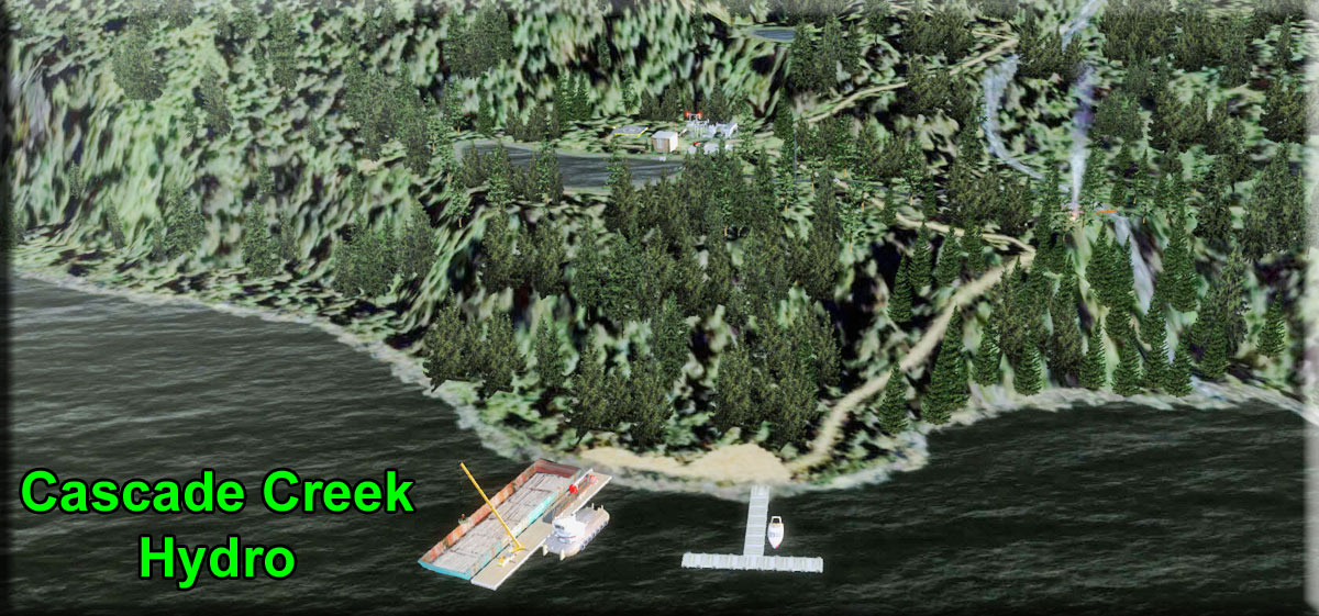
    Cascade Creek Hydro Project - PP11 - (Proposed) By Doug Linn
    (Refreshed V2.0-02.23.2019)

    This is a depiction of the "proposed" project for Cascade Creek. This is the creek starting from Swan Lake (the Swan Lake up near Petersburg). This is a "lake tap" type hydro. The lake level was only raised 5 feet, and there is a tunnel that comes from near the dam but "taps" the lake from the subsurface. The tunnel runs all the way down to the turbine house. The "tailings" for the tunnel are near the turbine house area. There are helipads at the plant and up at the lake and a dock for seaplanes at the dam, and another at the barge dock area. The document for this is the actual document for the Cascade Creek Project. See the overview map HERE.

    Map Button Document Button How to Install Button

    • Plant Dock: N57° 0.2090' ... W132° 47.1270' Mag: 273.9
    • Upper Reservoir: N57° 1.7648' ... W132° 44.4023' ... Mag: 254.4
    Goat Lake
    Click to Enlarge

    SeasonSwitch
    Jan Feb Mar
    Apr May Jun
    Jul Aug Sep
    Oct Nov Dec
    Legend

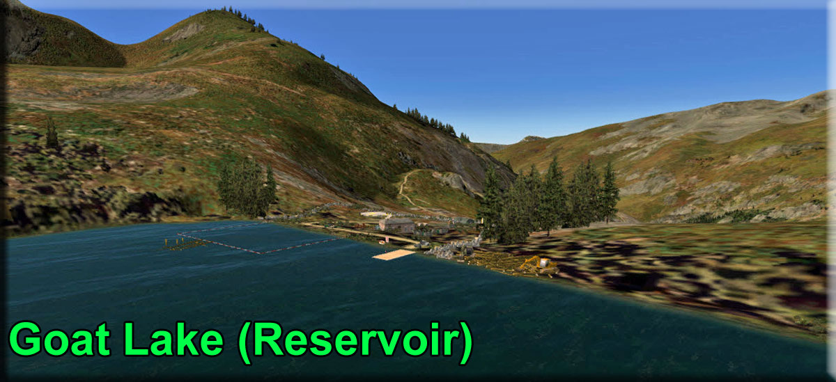
    Goat Lake Hydro - PP01 - By Thomas Menzel
    (Refreshed V2.0-02.19.2019)

    The Goat Lake hydroelectric facility is a storage project with a 4 MW capacity that started operations in 1997. The Lake is used as a reservoir without any dam. It was certified as a Low Impact Hydropower project by the Low Impact Hydropower Institute in 2007. Alaska Power & Telephone operates the Goat Lake facility, which provides power to Skagway and Haines. The Upper Lynn Canal's cornerstone is located seven miles north of Skagway. The 204-acre glacially-fed lake has the winter storage necessary to sustain year-round hydro generation. Goat Lake Hydro became operational in December 1997 and was interconnected with Haines via a 15-mile submarine cable in September 1998. The submarine cable was laid in Taiya Inlet, a fjord with depths up to 1,500 feet. This project allowed diesel-powered generators at both the Skagway and Haines plants to be quiet for the first time in nearly 80 years. (http://aptalaska.com)

    Map Button Document Button How to Install Button

    • Start: Upper Reservoir: N59° 31.6239' ... W135° 11.0500' ... Mag: 343.6
    Lake Dorothy
    Click to Enlarge

    SeasonSwitch
    Jan Feb Mar
    Apr May Jun
    Jul Aug Sep
    Oct Nov Dec
    Legend


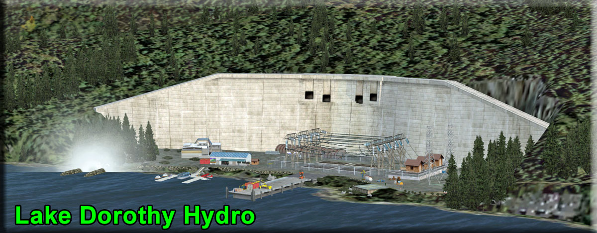
    Lake Dorothy Hydro - PP02 - by Thomas Menzel
    (Refreshed V2.0-02.19.2019)

    Lake Dorothy Hydro is located on the east bank of Taku Inlet, about 15 miles from Juneau. Except for 3.5 miles of its own transmission line, it utilizes a portion of the Snettisham transmission line to bring electricity into town. This 14.3 MW project, located near the Snettisham hydroelectric facilities near Juneau, increased the power supply to Juneau by 20 percent when it went online in 2009. The hydro project also provides power to Princess Cruise Lines and Greens Creek Mining Company

    Water from Lake Dorothy (2423ft) is used by taking advantage of the natural flow of water between Lake Dorothy, Lieuy Lake, and Bart Lake – a stair-step set of lakes feeding into Dorothy Creek. The side of Lake Dorothy was tapped 143 feet below the lake’s surface. This water flows through a 900-foot tunnel and through a large valve into an outlet pipe used to control the amount of water released to the natural drainage from Lake Dorothy into Lieuy Lake (1711ft) where it then follows the natural drainage into Bart Lake (986ft).

    At Bart Lake, a 34-foot high dam was constructed and water is diverted into a penstock to the powerhouse. The powerhouse houses a 14.3-megawatt generator. The project also includes a crew quarters and a substation. A road was built from the powerhouse to access the Bart Lake workings and for penstock installation.

    Map Button Document Button How to Install Button

    • Start: Lower Facility: N58° 13.8229' ... W134° 3.3011' ... Mag: 145
    • Start: Upper Reservoir: N58° 13.6228' ... W134° 1.3111' ... Mag: 253
    Mahoney Lake
    Click to Enlarge

    SeasonSwitch
    Jan Feb Mar
    Apr May Jun
    Jul Aug Sep
    Oct Nov Dec
    Legend

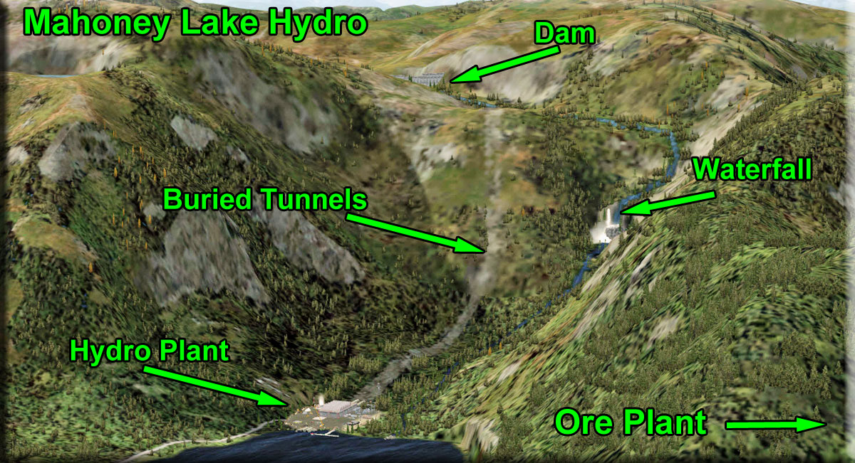
    Mahoney Lake Hydro - PP08 - (Proposed Facility near Ketchikan)
    By Doug Linn (Refreshed V2.0-02.22.2019)

    This is a proposed facility actually under construction. This comes complete with the plant, the tunnel system, a river and waterfall, and enhancement of the Niblick Ore Processing Plant which is used for staging for equipment and materials for the project. There is an access road that connects the project to the Ore Processing Plant, to be used for materials receiving and staging.

    Map Button Document Button How to Install Button

    • Start Plant Dock: N55° 25.1679' ... W131° 31.9041' ... Mag: 153.1
    • Upper Reservoir: N55° 24.8432' ... W131° 33.3392' ... Mag: 181.6
    Reynolds Creek
    Click to Enlarge

    SeasonSwitch
    Jan Feb Mar
    Apr May Jun
    Jul Aug Sep
    Oct Nov Dec
    Legend

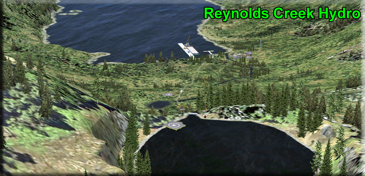
    Reynolds Creek Hydro - PP10 - (Under Construction) - By Doug Linn
    (Refreshed V2.0-02.22.2019)

    Reynolds Creek is under actual construction. It will basically server the Hydaburg Area. You will see these features:

    • 28 Ft Long, 6 foot High diversion structure at the outlet of Rich's Pond.
    • Lake Mellen and Rich's Pond provide 600 acre feet of storage
    • 42-inch diameter, 3200 ft long Penstock (Depicted under construction)
    • Powerhouse ... one 5 Megawatt Unit
    • Approximately 750 feet of Head Pressure
    • Ave Annual Energy Production is 19.3 million kilowatt-hours
    • Approximate Total Cost $22,750,000

    * You must use an amphibian if you are using a plane to taxi to Rich's Pond dock

    Map Button Document Button How to Install Button

    • Plant dock: N55° 12.9880' ... W132° 36.4340' ... Mag: 313.8
    • Reservoir dock: N55° 13.0713' ... W132° 35.3006' ... Mag: 151.8
    Ruth Lake
    Click to Enlarge

    SeasonSwitch
    Jan Feb Mar
    Apr May Jun
    Jul Aug Sep
    Oct Nov Dec
    Legend

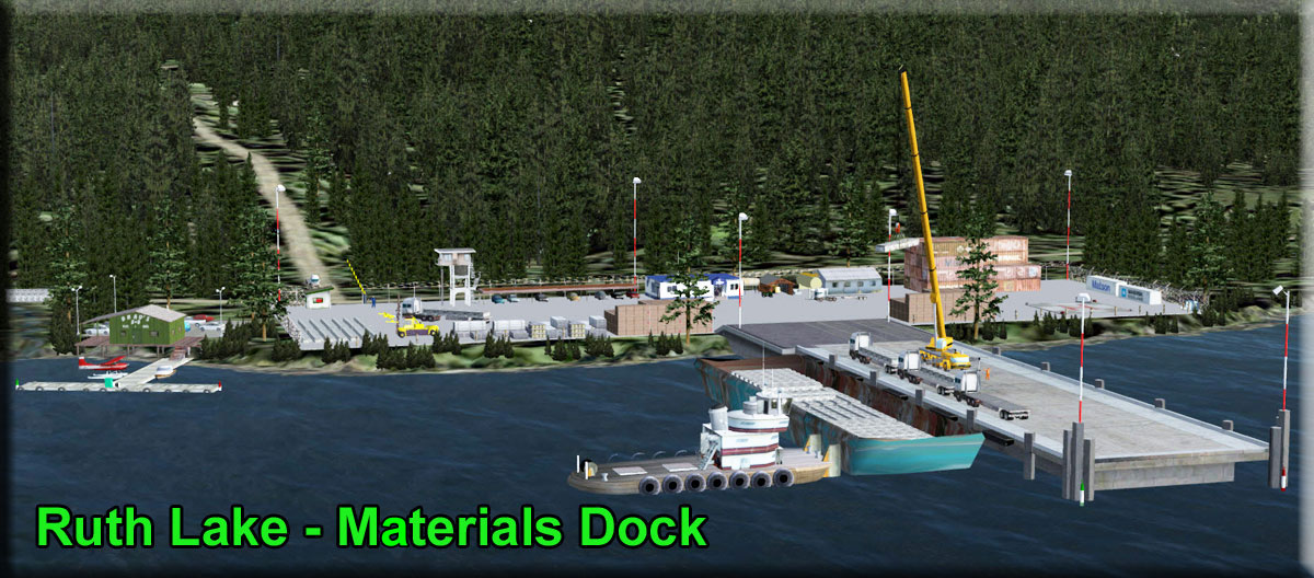
    Ruth Lake (Proposed) Hydroelectric Plant - PP06 - by Doug Linn
    (Refreshed V2.0-02.20.2019)

    This is a depiction of the proposed dam at Ruth Lake. This will supply Petersburg and Wrangel. There is a helipad at the dam construction site and another at the materials receiving dock (be careful with the high cranes and lights). You can tie the float plan up at Brad's BBQ near the Materials Receiving Dock. There is a "lake side" dock (on the lake side of the dam) where you can land on Ruth Lake and walk through the water tunnel to the construction site of the dam.

    Map Button Document Button How to Install Button

    • Start: Brad's BBQ N56° 58.4483' ... W132° 47.2125' ... Mag: 199.3
    • Start: Reservoir N56° 59.3275' ... W132° 44.3440' ... Mag: 99.6
    Salmon Creek
    Click to Enlarge

    SeasonSwitch
    Jan Feb Mar
    Apr May Jun
    Jul Aug Sep
    Oct Nov Dec
    Legend

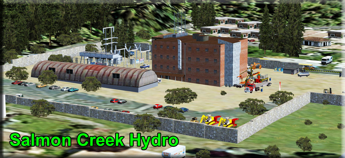
    Salmon Creek Hydro & Reservoir - PP14 -by Thomas Menzel
    (Refreshed V2.0-02.24.2019)

    The Salmon Creek Dam is a concrete arch dam on the Salmon Creek, 3 miles (5 km) northwest of Juneau, Alaska. Built in 1914, it is the world's first constant-angle arch variable radius dam. Since it was built, over 100 such dams have been constructed all over the world. The dam was built by the Alaska-Gastineau Mining Company to meet the electrical energy needs for mining operations. The dam continues to be fully functional for hydroelectric generation, as one of the drinking water sources to Juneau city and for aquaculture and fishing. When built, adoption of the constant arch design for the dam reduced costs by 20% because less concrete was needed to construct the dam. Of the two hydroelectric power stations built at the initial stage (one at the upper level and the other at the lower level) – the latter one is still in use after a new powerhouse was built adjoining the old one – it produces the inexpensive electricity in Alaska while meeting 10% of the energy needs of Juneau city. When built, the dam and its two power plants were considered engineering wonders. Both are operated and maintained by the Alaska Electric Light & Power (AEL&P).

    Map Button Document Button How to Install Button

    • Plant Dock: N58° 19.9230' ... W134° 28.3930' ... Mag: 337.3
    • Reservoir Dock: N58° 20.5882' ... W134° 24.1864' ... Mag 141.0
    Snettisham
    Click to Enlarge

    SeasonSwitch
    Jan Feb Mar
    Apr May Jun
    Jul Aug Sep
    Oct Nov Dec
    Legend

    Snettisham Hydro - 7AK2 (PP03) - by Thomas Menzel
    (Refreshed V2.0-02.19.2019)

    The Snettisham hydroelectric power plant is a 78,210 kW power plant located 28 miles south of central Juneau, Alaska and accessible only by boat or seaplane. The power plant is fed by two lakes that are tapped from below, negating the need for a traditional dam. It supplies most of the electricity for Alaska Electric Light & Power. It is connected to Juneau by at 44-mile transmission line. It was completed in 1975.

    This plant is located in an absolutely beautiful area and it has a fine airport 7AK2 that you can use for positioning your aircraft. There is a helipad at the dam on Crater Lake. There are also facilities for floatplanes and a helipad at the Snettisham (7AK2) airport. A Transmission Line was added to the Submarine Cable Station. (See Doc).

    Map Button Document Button How to Install Button Avalanche Report button Manual Season Switcher Button

    NOTAM: An avalanche scenario has been added as of 12.11.2015 (re-download and re-install if you don't have this or later version. Also make sure you have the latest APP Temp library). To see the avalanche automatically, you must use theRTMM Season Switcher. When the season is in summer and fall, you will not see anything different. When it is set to winter, you will see the avalanche. When the Season Switcher is set to spring, you will see the clean-up and repair crews working on the avalanche site. To see the avalanche without the season switcher, click on the Manual Season Switcher button above. To view the 2008 avalanche report for Snettisham, click on the 2008 Avalanche button.

    Start Upper Reservoir: N58° 9.9808' ... W133° 43.6656' ... Mag 251.8
    Start Lower Plant Dock: N58° 8.4106' ... W133° 44.2158' ... Mag: 265.7
    Start SPB: N58° 8.3060' ... W133° 43.7861' ... Mag 76.8

    Swan Lake
    Click to Enlarge
    SeasonSwitch
    Jan Feb Mar
    Apr May Jun
    Jul Aug Sep
    Oct Nov Dec
    Legend

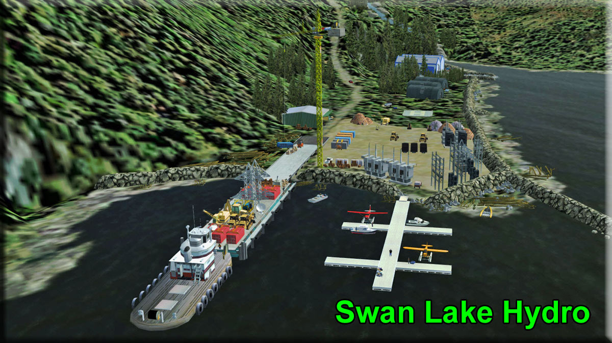
    Swan Lake Hydro - PP05 - by Thomas Menzel
    (Refreshed V2.0-02.20.2019)

    The Swan Lake Hydroelectric Facility is located on Revillagigedo Island at the head of Carroll Inlet, about 22 miles northeast of the City of Ketchikan.  Primary facilities include:

    • reservoir with a surface of 1,500 acres at normal maximum elevation and usable storage capacity of 86,000 acre-feet between elevations 330’ and 271.5’
    • 174’ high concrete thin arch dam (430’ long at its crest)
    • uncontrolled ogee spillway section, 100’ long with a crest elevation of 330’
    • 2,217’ long, 11’ diameter power tunnel
    • powerhouse with two Francis turbine generating units having a combined nominal generating capacity of 25 megawatts (MW)
    • 13.8/115-kV substation located adjacent to the powerhouse
    • port facilities 1000’ north of the powerhouse, a staging area adjacent to the port facilities, and access roads from the port facilities to the powerhouse and dam
    • 115 kV transmission line extending from the powerhouse substation 30.5 miles to the existing S.W. Bailey Substation.

    Map Button Document Button How to Install Button

    • Start at plant outfall pier: Use GoTo PP05
    • Reservoir: N55° 36.9117' ... W131° 20.6517' ... Mag: 215.7
    Takatz Lake
    Click to Enlarge

    SeasonSwitch
    Jan Feb Mar
    Apr May Jun
    Jul Aug Sep
    Oct Nov Dec
    Legend

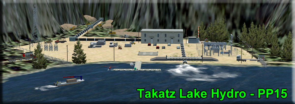
    Takatz Lake Hydro - PP15 - (Proposed site) By Doug Linn
    (Refreshed V2.0-02.23.2019)

    Takatz Lake is located approximately 4,000 feet upstream of the mouth of Takatz Creek which flows into Chatham Strait by way of Takatz Bay on the eastern shore of Baranof Island. The normal water surface of the lake is at approximately 840 feet. Construction of a concrete arch dam approximately 200 feet high at the existing outlet of the lake would raise the lake level to El 1040. A "saddle dam" will be needed just adjacent to maintain the 200 feet. The reservoir would contain active storage of volume of approximately 82,400 acre-feet.


    Water would be withdrawn through a lake tap into an approximately 2,800 foot-long, 6.5 foot by 7 foot modified horseshoe tunnel. The tunnel’s downstream portal would connect to a 72-inch diameter, 1000 foot-long steel penstock leading to the powerhouse.

    This facility has three separate locations, the dam, the power plant, and the materials dock.

    Map Button Document Button How to Install Button

    • Plant Dock: N57° 8.0296' ... W134° 50.1218' ... Mag: 219.6
    • Reservoir: N57° 7.7454' ... W134° 53.3987' ... Mag: 306.9
    Thayer Creek
    Click to Enlarge

    SeasonSwitch
    Jan Feb Mar
    Apr May Jun
    Jul Aug Sep
    Oct Nov Dec
    Legend

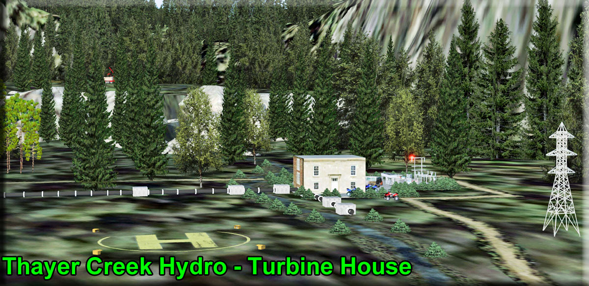
    Thayer Creek (Proposed) Hydro - PP07 - by Doug Linn
    (Refreshed V2.0-02.20.2019)

    A Small "community" hydro plant under construction and almost completed. This plant will cost about $1,000,000. The local workers have cleared a trail along the creek and built an earthen breastwork (dam) above the falls. They have then constructed a small 150' by 150' turbine house that holds 5 generators. There is a power line connecting this plant to the community of Angoon, 6 miles to the south. A float plan can land at the small dock area, but only helicopters can land at the power plant and at the dam construction site.

    Map Button Document Button How to Install Button

    • Outfall Pier Start: N57° 34.7300' ... W134° 37.5805' ... MAG: 359.3
    • Upper Reservoir: N57° 35.4349' ... W134° 37.2603' ... MAG: 180.3
    Triangle Lake
    Click to Enlarge

    SeasonSwitch
    Jan Feb Mar
    Apr May Jun
    Jul Aug Sep
    Oct Nov Dec
    Legend

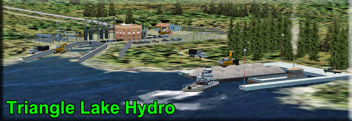
    Triangle Lake Hydro - PP12 - By Doug Linn (Proposed Site)
    (Refreshed V2.0-02.23.2019)

    It is called the "Triangle Lake Project" but the actual lake's name is "Hassler Lake" on Annette Island. A lake tap hydro. The lake is dammed up at its low edge and a spillway is created there. Then a penstock "taps" the lake and runs underground down to the hydro plant at Hassler Inlet. There is a Brad's BBQ there for a BBQ and beer for the workers and on-lookers should they happen by in their boats to watch the construction.

    Map Button Document Button How to Install Button

    • Plant Dock: N55° 12.7472' ... W131° 26.4555' ... Mag: 290.2
    • Reservoir: N55° 11.8633' ,,, W131° 27.7932' ... Mag: 292.2
    Tyee Lake
    Click to Enlarge

    SeasonSwitch
    Jan Feb Mar
    Apr May Jun
    Jul Aug Sep
    Oct Nov Dec
    Legend

    Tyee Lake Hydro - PP04 - by Thomas Menzel
    (Refreshed V2.0-02.19.2019)

    The Tyee Lake Hydroelectric Project is located at the head of Bradfield Canal, approximately 40 miles southeast of Wrangell, 60 air miles northeast of Ketchikan, and 70 air miles southeast of Petersburg. Tyee Lake is a natural lake used as a storage reservoir with 15 square miles of drainage area, 52,400 acre-feet of active storage, and a normal water surface elevation of 1,396.0 feet at full pool. Unlike the Swan Hydro Facility which is a dam, the Tyee project is a “lake tap” with an installed capacity of 25 MW. Water is conducted to the powerhouse through an intake from the lake into a drop shaft, through an 8,300’ long unlined power tunnel and a 1,350’ long steel penstock, which houses two generating units.

    The project site is accessible only by air or boat and includes a powerhouse, substation, employee housing, warehouse, maintenance shop, incinerator building, fuel storage and dispensing area, barge dock, an airstrip, and is located along a narrow bench of land between the tidal estuary of the Bradfield River and a steep mountainside.

    Map Button Document Button How to Install Button

    • Reservoir: Use Tyee Lake Hydro / PP04
    • Outfall Pier: N56° 13.0637' ... W131° 29.4547' ... Mag: 96.1
    Whitman Lake
    Click to Enlarge

    SeasonSwitch
    Jan Feb Mar
    Apr May Jun
    Jul Aug Sep
    Oct Nov Dec
    Legend

    Whitman Lake Hydro - PP09 - (Under Actual Construction)
    by Doug Linn (Refreshed V2.0-02.23.2019)

    Whitman Lake Hydro is a small facility located "behind" Herring Bay. There is a spillway up at Whitman Lake and a penstock coming down to a plant with two units. It is located beside a fish hatchery ... the water from the lake supplies both the power plant and the hatchery. Original Project Project Presentation HERE, Project Map HERE.

    NOTAM: This is a SEPARATE zip file and addition. It CANNOT be used if you have the "commercial" PAKT installed, the elevations will be all wrong. That is why this is separate. Treat it like any other RTMM download. Just click on the "zip" button below and install it per usual.

    Map Button Document Button How to Install Button

    • Start Reservoir dock: N55° 19.9972' ... W131° 31.9366'... Mag: 274.1
    Back to Top
    Other RTMM Hydro Plants - Stand-alone downloads
    • NOTAM: These three locations are hydro plants that were done previously at RTMM. They are here so you can add them to your hydro plant collection. They are stand-alone downloads like all other RTMM Scenery.
    Big Fall Hydro - (Updated 06.16.2014)
    by Doug Linn

    Here is the Big Fall Hydro complex scenery package. It consists of four "locations": (1) The Hydro Plant, (2) The Waterfall (Big Fall), (3) A Brad's Bait & BBQ (our third) and (4) a cozy cabin across the lake from the action to watch it all from a quiet porch beside a warm campfire.

    This location is accessible by floatplane, boat or helicopter (there are two helipads). It is about 30 miles from Prince Rupert on a bearing of 105 degrees.

    Be sure to check out the power plant after dark ... it's lit up rather well.

    Map Button

    Bradley Lake Hydro (Updated 07.27.2015)
    By Doug Linn & Rod Jackson

    Bradley Lake is about 14 miles northeast of Halibut Cove. Bradley Lake is a glacial lake taking the runoff from the Kachemak Glacier. The lake was dammed and a tunnel was built through the mountain toward the ocean on the other side. There the water comes out of the tunnel and goes into hydroelectric generators, then outflows to a stream that goes down the mountain and to the sea. The whole story of the hydroelectric project is in the Readme that comes with the scenery. This is a great side trip from beautiful Halibut Cove.

    Map Button

    Ocean Falls HydroClick to Enlarge
    cean Falls, BC (Updated 04.11.2015 - Med Facility Added)
    By Doug Linn

    We have tried to duplicate Ocean Falls, BC as closely as we can with the objects we have. There is a dam that backs up a very beautiful lake. The dam has a generating station that produces electricity for the region. As you fly to this location, you'll notice many power line poles on the port shoreline ... all coming from Ocean falls.

    It seems the cruise ships have discovered it too, as one is anchored in the cove allowing passengers to embark to shore to visit the dam and the shops in the town.

    Map Button

    Back to Top
    Power Plant Dispatches and Scenic Flight Plans

    helicopter buttonHelicopter Power Plant Dispatches: Klaus Troeppner's detailed instructions will give you exactly the directions you will need to safely find and land at the many helipads in this scenery set. His approaches will give you an up-close view of the many details that are scattered throughout these locations.

    Float Plane IconFloatPlane Power Plant Dispatches: Doug Linn will give you instructions on finding the plants and tips on how to approach the tricky reservoirs where the lake taps and dams are located. Doug also adds a "Slew & Find" feature for each location. You can leave the aircraft and slew around to view the area, then return to exactly where you were (see viewing tips below).

    telescope iconViewing Tips for floatplanes: There is no way you can see the details of many of these plants from a floatplane. We have added "Viewing Tips" so floatplane pilots can explore the many details. We will use "Go to Airport" (GTA) and the ICAO and start position. (GTA=PP14/W Helipad) means use Go to Airport and select Airport PP14 and the "W Helipad". Once you are there, go into slew mode and look around. We will always put you back to where you started exploring.

    Map Button: Clicking on the Map button will give you an overview of the area you will be covering in the dispatch.

    Print ButtonPrint Button: We have created a PDF for each of the dispatches. So rather than referring to the web page for your instructions, you can click on the print button and a PDF will appear that you can print. (If the PRINT button is not present, the dispatch is not yet finished)

    Dispatches **

    • NOTAM: (Click on Dispatch Number to View. These are hard-linked to the page so selecting one takes you to that particular dispatch's table ... click on the bottom line to come back to this table.)
    Dispatch #
    Area
    Plants
    PPD-01 Skagway Area Goat Creek Hydro
    PPD-02 Juneau Area Salmon Creek, Annex Creek, Lake Dorothy, Snettisham
    PPD-03 Angoon Area Thayer Creek, Takatz Lake
    PPD-04 Sitka Area Blue Lake Hydro
    PPD-05 Petersburg Area Cascade Creek, Ruth Lake, Tyee Lake
    PPD-06 Ketchikan Area Swan Lake, Mahoney Lake, Whitman Lake Triangle Lake
    PPD-07 Prince of Wales Reynolds Creek Hydro

    Scenic Flight Plans **

    • INSTALLATION: Click on the Flight Plan name to download a small zip the flight plan. Add the flight plan to the documents folder for your flight simulator. Click on the "see instructions" to see the turn by turn instructions.
      • FSX = .../Documents/Flight Simulator X Files
      • P3D - ... /Documents/Prepare3D V2 Files
      • Click on Link for the "Scenic Flight #" to download. Click on the PDF to view the flight instructions.
    Scenic Flt. #
    Area Covered
    PDF
    VFR 001 Skagway Area - Goat Lake Hydro PDF
    VFR 002 Juneau Area-Salmon Creek, Annex Creek, Lk Dorothy, Snettisham PDF
    VFR 003 Sitka Area-Blue Lake, Takatz Lake, Thayer Creek PDF
    VFR 004 Admiralty Island Area (not active) PDF
    VFR 005 Petersburg Area (not active) PDF
    VFR 006 Ketchikan Area-Swan Lk, Mahoney Lk, Whitman Lk, Triangle Lk PDF
    VFR 007 Prince of Wales Area - Reynolds Creek Hydro PDF

    ** NOTAM: DISPATCHES vs. SCENIC FLIGHT PLANS (What's the difference?).

      • DISPATCHES - These take a great deal of piloting and are more realistic for the advanced sim pilot. Dispatches put you down onto the plant complex, landing at the facilities and exploring them. Mostly recommended for helicopters and floatplanes.
      • SCENIC FLIGHT PLANS - Are Plan-G autopilot flights that take you "over" the power plant areas. Scenic Flights can use the autopilot so, other than changing altitude, you can sit back, relax and see the areas where the plants are located. But these do not take you "down to the complex." Mostly recommended for floatplanes or higher level helicopter scenic operations.
    Back to Top

    Map Button.

    Goat Lake PP01 - floatplanes start at Haines SPB (3Z9). Helicopters start at PAHN. Set PP01 as your "GO TO" waypoint on the GPS. Fly into the Lynn Canal and into the Taiya Inlet to Skagway. Turn to port and follow the Skagway River 6 miles to PP01.

    helicopter button Helicopter - By Klaus Troeppner

    1. Start at PAHN Haines. The airport offers several helipads.
    2. Set GPS for PP01 Goat Lake Hydro. Lift off and after passing the town of Haines, set your course heading north and follow the Taya Inlet to Skagway
    3. Leaving Skagway behind follow the White Pass along the white pass railroad. Be aware of reduced maneuverability while following the pass and set airspeed to the max. 80-90 knots, altitude about 1000 ft above ground.
    4. After two miles the hydro plant comes into sight just right aside the railroad. Reduce airspeed to 50-60 knots and start your approach with the railroad as a visual reference. Watch out for tall trees around the site. Also, fog is a known condition there.
    5. Stop in a hover about 50 feet above the railroad next to the hydro plant. Then hover turn for 90 degrees to the right and you will see the helipad below in 12 o`clock position.
    6. Descent slowly while hover taxing to the concrete helipad and touch down. Watch out for tall obstacles at the site.
    7. Lift off again. Hover and slightly climb in a backward hover taxi till your heli is straight over the railroad again. Then turn for 90 degrees to the right and accelerate into translational lift.
    8. Climb while following the white pass heading to Skagway. When almost reaching the top of the mountains turn right for 180 degrees and fly back to the hydro site.
    9. A few hundred feet above the hydro plant you will now have the goat lake and the dam construction to the right in sight.
    10. Start your approach at about 60 knots airspeed on the helipad located about 100 ft in front of the dam.
    11. touch down on the helipad. Watch out for loose construction materials around the helipad.
    12. For leaving the dam site again, lift off and adjust forward flight into translational lift. Turn slight to the left and follow the goat lake till airspeed is about 60-80 kts.
    13. Turn left in a moderate bank turn for 180 degrees. After leaving the turn you follow again the white pass to Skagway. Land at PAGY or TEMSCO heliport and finish your flight.

    Float Plane Logo Floatplane - By Doug Linn

    1. Set the GPS for "PP01" (Goat Lake Hydro). Start at 3Z9 (Haines, AK SPB)
    2. Take off on about a 0° bearing heading for 5 NM. Suggested Altitude 1200 Feet Starting in the Chilkoote Channel and heading for the Taiya Inlet that you will follow all the way to Skagway, AK ... distance to Skagway, 15 NM.
    3. You will turn to starboard into the East Fork of the Skagway River.
    4. Weather permitting, raise altitude to 3000 feet (the landing zone is at 2919 feet)
    5. Six miles from the Skagway Airport, watch for a zigzagging road to the starboard of the railroad track. Turn to starboard and follow the road to Goat Lake.
    6. You should fly over the dam at Goat Lake. A hard turn to port will then line you up on the lake for a landing.
    • telescope iconVIEWING TIP: (GTA=S Helipad). You can view the plant, not accessible by floatplane. Slew around and enjoy the location. When finished use (GTA=PP01/33 water) to return to the reservoir dam dock.
    Back to Top of Dispatches

    Map Button.

    helicopter button Helicopter - By Klaus Troeppner


    Salmon Creek Hydro PP14..........

    • NOTAM: helipad`s on this site should be approached with light and medium helicopters due to small landing zones! Check latest METAR before Flight, high winds and fog are possible.


    1. Start at PAJN Juneau airport or TEMSCO Heliport. The airport offers several helipads.
    2. Set GPS for PP14 Salmon Creek Hydro. Lift off and after passing the airport area, set your course heading 110-120 degrees and follow the highway on cruise speed in direction to Juneau Harbor (5Z1).
    3. Watch out for a radio transmission tower in front after about 3 miles. Set airspeed to max. 50-60 knots, altitude about 200-300 ft above ground when arriving at the tower.
    4. Pass the tower to the right and turn hard for about 90 degrees. Continue reducing airspeed to 30-40 knots just above translational lift. Be aware of obstacles like trees and lighting poles in the area.
    5. You should now see the power plant building surrounded by a big stone wall in 1 o`clock position. look out for the helipad in the yard and start your approach slowly. Be sure passing the wall on safe altitude then hover over the helipad and touch down.
    6. Lift off vertically again for the dam site to altitude 150-200 feet. Then hover turn for 45 degrees to the left. Accelerate into translational lift and follow the river and road you see in 12 o`clock position up the pass.
    7. After about 2 miles watch out for a small site (building, Cargo, Materials) in front of you just before the pass turns slightly to the left. Keep eyes open, the site is well surrounded by tall trees. (Tip: In case helipad is out of sight on vertical descent, use the small earth wall or the building to the right as visual references.)
    8. Hoverstop in front of the building. Helipad is just behind it. Slowly hover over the helipad at altitude of about 200 feet above ground. Then continue vertical descent slowly and finally touchdown on the helipad.
    9. Lift off again in a vertical climb to about 200-250 feet above ground. In Hover turn to the left for about 30 degrees and accelerate into translational lift.
    10.Again follow the river you see in front at about 70-80 knots. after a slight right turn the dam comes into sight after one mile.
    11.You see the helipad in front of a cabin right of the dam. Start your approach to the helipad. (Warning: the helipad is surrounded by large trees in three directions. Only approach from the lake side is recommended!)
    12.Touch down slowly on the helipad. Watch out for loose construction materials around the helipad.
    13.For leaving the dam site again, lift off in backward hover taxi. As soon you are moved back on the lake, climb and adjust forward flight into translational lift. Turn slight to the left and follow the pass down to Juneau.
    14.Continue flight for Annex Creek Hydro.

    Annex Creek Hydro PP13...........

    1. Set GPS for PP13 Annex Creek Hydro.
    2. There are two recommended routes for helicopters to the hydro plant.
    a) (The good weather route) Pass Juneau harbor on cruise speed to Thane. At Thane turn left for 90 degrees and follow the valley. After about two miles watch out for the transmission line or follow your GPS heading to Annex Creek.
    b) (The bad weather route) Pass Juneau harbor and follow Gastineau Channel at about 500 ft at cruise speed to its outcome into Taku Inlet. Then left and follow the coastline till reaching Annex Creek.
    3. Pass the Annex Creek Power plant and Camp site and watch out for the helipad, then turn into a hard right bank turn for 270 degrees. Slow down airspeed and altitude. At end of turn speed should be about 50 kts, altitude at 200 ft.
    4. With the helipad now in front at the Camp site, start your approach and touch down.
    5. Lift off again and hoverturn for 180 degrees. Adjust forward flight into translational lift and accelerate to cruise speed and altitude.
    6. Turn into a hard bank turn to the right for 180 degrees again. At the end of the turn you should see Annex Creek in front of you. Follow the greek up the mountain. Maintain speed at 60-80 knots.
    7. At the end of Annex Creek about 200 ft above water, there`s the valve house o`clock in sight. As soon as you see the helipad in front of the house, start your approach.
    8. Hover over the helipad at 10 feet and turn heli into wind, then touch down.
    9. Lift off and accelerate into translational lift. Move to the dam and hover over the site. Check the dam site then follow Annex Creek while setting speed up to cruise and fly to Taku Inlet.

    Lake Dorothy Hydro PP02..........

    1. Set GPS for PP02 Lake Dorothy Lake Hydro.
    2. When the Lake Dorothy power plant comes in sight, turn right to the south and follow the transmission line along coast for about 5 miles.
    3. To the left the submarine cable station while come in sight. Pass it and turn in a hard right bank turn while descending speed to 50 knots, altitude at 150 feet.
    4. Approach the helipad now in 12 o`clock position and touchdown. Watch out for tall trees in the landing zone.
    5. Lift off again in a slight backward hovertaxi. Hoverturn to the left for 90 degrees after crossing the shoreline, then adjust speed to cruise range, altitude at about 500 ft.
    6. Follow the transmission line along the coast back to the Annex Creek power plant site.
    7. With two miles the power plant in front, reduce airspeed and prepare for approach.
    8. Hoverstop with the power plant just beside the power plant in 3 o`clock position.
    9. Hoverturn right for 90 degrees and continue approach to the helipad in front, then touchdown. Be aware of vehicles and personnel in the landing zone.
    10.Lift off, turn the right for 90 degrees and accelerate in a steady climb bank turn for 270 degrees.
    11.At the end of the turn the power plant and a road is in 12 o`clock position.
    12.With airspeed at about 80 kts and altitude above 300 feet follow the road up to Bart lake.
    13.As soon as Bart lake dam is in sight reduce airspeed to 50 kts and watch out for the helipad. Warning: Be aware of the tall trees nearby the helipad. You will enter a small landing zone!!
    14.The helipad is located nearby a small cabin beside the road. Hoverstop and start a vertical descent over the helipad. (Tip: use the cabin as visual reference as long you do not see the helipad just under your helicopter!)
    15.Touch down on the helipad.
    16.Lift off again in a vertical climb. Be aware of the nearby trees while climbing!
    17.At 250 feet above ground accelerate into translational lift and set your course over Bart lake and climb up to Lieau lake.
    18.Leaving Lieau Lake behind, continue climbing to Lake Dorothy.
    19.Passing the dam up at Lake Dorothy and watching out for the helipad by the cabin, turn left into a hard bank turn. Reduce airspeed to 40-50 kts, altitude above water at 100-150 feet.
    20.Do your approach to the helipad and touchdown.
    21.Lift off again and accelerate to cruise speed while turning left flying over lake Dorothy.

    Snettisham Hydro PP03 (GPS=7AK2)..........

    1. Set GPS for 7AK2 Snettisham Hydro and continue your flight.
    2. At the end of Lake Dorothy climb over the Mountaintops in front then turn left for 90 degrees and follow the valley.
    3. Follow the next valley to the right and you will flying over Long Lake. At the end of Long Lake is the dam with a helipad.
    4. Approach to the dam and watch out for the helipad just right aside.
    5. Touchdown on the helipad. Be aware of tall trees and loose materials at the side.
    6. Lift off in a backward climb to an altitude about 200 feet over water.
    7. Turn slightly left, accelerate into translational lift, pass the dam and fly down along the valley to Snettisham 7AK2. Tip: use 7AK2 as visual reference when in sight.
    8. After moderate right and left turns you should see 7AK2 in 12 o`clock position after about 1 mile.
    9. Pass ZAK2 runway and then turn in a hard left bank turn for about 230 degrees. Pass the airport helipad and fly at about 60 kts to the power plant site which is now in 12 o`clock position just 0.5 miles behind the runway.
    10.Do your approach to the power plant and hoverstop over the river just in front of the plant.
    11.The power plant helipad is below in 2 o`clock position. Warning: Small landing zone! Beware of tall trees!!
    12.Turn right for 45 degrees while descending slowly down to helipad and touchdown.
    13.Lift off again in a vertical climb till you are over the tree tops. Turn right for 90 degrees and accelerate to translational lift.
    14.Fly to 7 AK2 helipad. Land there and finish the Flight.

    Float Plane Logo floatplane - By Doug Linn

    Salmon Lake Hydro PP14 ............................

    1. Start at PAJ1 (Juneau International SPB)

    2. Salmon Creek Hydro: Set PP14 into the GPS. The hydro plant is very well-integrated into Juneau. The dock for the hydro plant is near the water outfall, but located about 4 blocks from the plant. As you approach the community, you will cross over a 4 lane highway and land in the lagoon just before the community but beyond the highway. You will see a small dock there for the Hydro Plant, that is the "Water W" dock for the plant.

    3. After landing at the dock, look toward the mountains and you will see there is a gap there. The dam is at Salmon Lake above Juneau in that gap.

    • telescope iconVIEWING TIP: Without a helicopter, the facilities here are difficult to see and should be visited. (1) To see the Hydro Plant, do a "Go to Airport" (GTA) you can slew around and look at the details. (2) To view the pumping station, use (GTA=PP14/NW Helipad). (3) When finished, use ( GTA PP14/Water W) and it will put you at the hydro plant dock so you can continue your journey.

    4. Take off from the Salmon Lake hydro plant dock and fly out of the little lagoon, then fly back over the dock area headed toward the gap in the mountains. Watching below, you will see the Salmon Creek outfall and will pass directly over the Salmon Creek Hydro Plant and the upper pumping station. The creek will lead you to Salmon Lake where you can land behind the dam.

    • telescope iconVIEWING TIP: Once parked at the dock up by the Salmon Lake Dam. Again, slew your aircraft and look at the base of the dam on the other side. You will find a small park there with little bridges, even a camper with a campfire. This is an actual camping area. Then use (GTA=PP14/E. Water) to go back to the dam mooring.

    Annex Creek Hydro PP13 ......................

    1. At the Salmon Creek Dam Dock, set PP13 for Annex Creek Hydro into the GPS. You are going to fly to the loading dock of Annex Creek Hydro. If the weather is good, you can fly high and go directly to it. If the weather is not good, then fly back down over the Salmon Creek Plant Dock and turn to port following the Gasteneau channel past Juneau. (Suggested altitude 1200 feet). (If you are flying the Gasteneau Channel, as you take off, fly low over Salmon Creek back down the mountain and you can see the entire location laid out for you).

    2. When you come to the end of the Gasteneau Channel, turn to port around Bishop Point into the Taku Inlet. Stay to the port side of the inlet. The plant is 8 miles ahead. As you come into the Taku Channel, you can start moving toward landing altitude. As you approach Annex Creek, look to port and you will see a canyon with a stream coming through it. We will be coming back to this in the next leg. Land at Annex Creek and tie up at the dock there.

    • telescope iconVIEWING TIP: This is a fascinating (and real) small community that has been created for you here. You might want to get out of your plane and "slew around" to look at all of the many details in this dockage area. to return (GTA=PP13/E Water)

    3. Leaving the Annex Hydro Dock, you will take off in the direction from which you came on a bearing of about 185°. The outfall you passed on landing is now to your starboard. Turn and follow the creek up the mountain. It will come to a small lake, then you will see a higher lake ahead and to starboard. The dam for this lake is at the leading edge of the lake. Plan to land near the dam.

    Lake Dorothy Hydro PP02 .........................

    1. At the reservoir dock for Annex Creek, set the GPS for PP02 (Lake Dorothy Hydro). Taxi toward the middle of the lake then turn and take off over the dam. You will fly across the Taku Channel to Lake Dorothy on the far side. There is a dock right in front of the hydro complex to the right of the outfall.

    • telescope iconViewing Tips: From the position in front of the complex, slew around and look at the immediate area. Look for a road coming out of the plant complex to the right of the complex (as you are facing it). Follow that road in slew and it takes you up to the Lake Dorothy dam area. This is a great lake to land upon. Now go back to the position in front of the complex. (GTA=PP02 / active runway).

    2. You next fly up to the reservoir at Lake Dorothy. Watch for a road behind the complex that goes up into a lowered are of the mountains. That road then climbs and turns to port. Lake Dorothy is at 1100 feet. Be careful upon landing as there are many obstacles (logs, etc) in the water there. Land and taxi up to the dam area. You will find a small dock to the left of the dam.

    3. Take off from the dam area on a heading of about 250° and fly back over the power plant. Then turn to port and follow the coast for 2.2 miles and land near the subterranean cable building on the coast there. (GTA=PP02 / E Water)

    Snettisham Hydro PP03 .........................

    1. While at the cable station dock, (GTA=PP02 / E Water), set 7AK2 (Snettisham) into the GPS.

    2. There are high mountains between your present position and Snettisham. The best way to fly is low over water. As you leave the cable station, stay close to the coastline, keeping it to port. You will pass by past Taku Harbor airport (A43). Continue another 8 miles to Port Smettisham (a large inlet to port). Fly into the inlet. The inlet forms a "T". The right leg goes to Gilbert Bay and the left leg goes to 7AK2, Snettisham airport. There is a dock to land at to the left of and past the airport runway. (If you have an amphibian you can land, it is a hard surface). Park at the dock. There are people and packages on the dock.

    • telescope iconViewing Tips: Go into slew mode and look around the area. The hydro plant is to your left as you face the coast. There is a lovely small area where the penstock tunnel comes out of the mountain where there are cabins. Slewing back toward the airport (to the right) ... go back into the community and check out the saw mill and the logging areas. Further to the right you'll find a small cabin. Go back to position (GTA=PP03 / S Water).

    3. Leave the dock, take off and fly up to the reservoir. You can follow the road that comes out the back of the saw mill. It will lead you around the mountain and up to the reservoir. Land on the reservoir and taxi to and park at the dock there.

    4. After taking a breather, it is time to head back to Juneau. Set your GPS for PAJ1 and fly back to Juneau International SPB.

    Back to Top of Dispatches

    Map Button.

    helicopter button Helicopter - By Klaus Troeppner

    Thayer Creek Hydro PP07 ...................
    1. Start at PP07 Helipad #3. This is a helipad at the dock in Angoon Harbor.
    2. Set GPS for PP07 and fly to Thayer Creek Hydro by following the coast line and the transmission line to the north.
    3. When passing the power plant turn left in 270 degree bank turn and decelerate. At the end of the turn you should see the power plant in 12 o`clock with speed at 50-60 knots, altitude at about 300 feet.
    4. Fly up to Helipad#2 at 40-60 knots at the turbine house. Be aware of tall trees around the landing zone. When the concrete helipad comes into sight on to the left reduce airspeed and land there.
    5. Lift off again. Adjust forward flight for translational lift and fly at 40-50 knots up to the dam. As reference follow the river. Be aware of tall trees.
    6. After about 500 m the helipad comes into sight. Watch out for moving construction vehicles in front of the helipad.
    7. Reduce speed into a hover and touch down on the helipad.

    Takatz Lake Hydro PP15 ........................

    1. Set the GPS for PP15 (Takatz Lake Hydro) and fly to the Takatz hydro dock facility.
    2. When the dock facility comes into sight descent speed on approach to 50-60 knots. Watch out for cargo ships at the site.
    3. Turn right and descent to hover on the helipad and touch down. Be aware of construction vehicles and cranes.
    4. Lift off and hover turn 180 degree over the helipad. Adjust forward flight into translational lift.
    5. Turn right to 90 degree and accelerate. Follow the construction road to the Power plant.
    6. Decelerate on approach. At the power plant site turn left for 90 degrees and descent to hover on the helipad and touch down. Be aware of construction vehicles at the site.
    7. Lift off and hover turn 180 degree over the helipad. Adjust forward flight into translational lift. After passing the pier turn left for 90 degrees and fly to the dam site.
    8. Follow the construction road up to the dam. Pass the dam and follow the lake. Where the lake turns to the right, do a 180 degree turn at about 80 knots.
    9. Return to the dam and decelerate to 50-50 knots with the helipad coming into sight to the left of the dam.
    10. Descent to hover and touch down on the concrete helipad.

    Float Plane Logo floatplane - By Doug Linn

    Thayer Creek Hydro PP07 ....................

    1. Start at the Angoon Dock (GTA=AGN/Dock 1)

    2. Take off on a 335° bearing. Watch for the power lines and follow them to the Thayer Creek area. Stay at low altitude because you will land 5 miles ahead, just off shore. Follow the coastline (to starboard) until you come to the Thayer Creek Outfall. Land and taxi to the dock.

    • telescope iconViewing Tip: The best way to view this complex is with slew at a low altitude following Thayer Creek from the outfall up to the reservoir. You will see the buildings where the workers are lodged to the left of the creek just before the powerhouse. Notice the penstock coming from under the ridge to the left. Follow the creek up to the reservoir. You will see them cutting, stacking and burning logs as they clear land for the penstock. You will eventually come to the reservoir. Notice there is a water dock there and a cabin directly across the reservoir. To return to the Thayer Creek Loading Dock (GTA=PP07/Parking 1)

    3. Take off from the loading dock and fly low up to the Thayer Creek reservoir. You will find a dock near the outfall of the reservoir and a small cabin directly across from it. If you would like to stay overnight, you are welcome to stay at the cabin.

    Takatz Lake Hydro PP15 ......................

    1. Put PP15 into the GPS and fly to Takaz Lake Hydro, landing just off shore and taxiing to the dock.

    • telescope iconViewing Tip: Go into SLEW mode and follow the road to the right of the power plant. It will go up to the dam where the construction can be viewed. Look "behind" the dam to see the construction happening. Notice the "saddle dam" beside the main dam (explained in doc). To return to the parking at the plant (GTA=PP15/1 Water).
    • There is a Materials Loading Dock. From the plant dock, slew to the left of the plant following the road to the materials handling dock. You will see much construction activity at this dock area. Once you are done looking around, go back to the plant dock (GTA=PP15/1 Water).

    2. You can now fly up to the dam, landing behind it and taxiing to the dock there. You can fly from there to the materials handling dock and taxi to the dock located there. Use the roads to find the facilities. Facing the plant, follow the road to the right up to the dam or follow the road to the left to the materials handling dock.

    3. When you are ready to leave the facility, put A29 into your GPS for the Sitka SPB. Take off and fly to Sitka.

    Back to Top of Dispatches

    Map Button.

    helicopter button Helicopter - by Klaus Troeppner


    1.Start at PASI Rocky Gutierrez Airport, Sitka.
    2.Set GPS for PP16 Blue Lake Hydro. Lift off into translational lift and fly heading east at 070 - 080.
    3.After about 4 miles turn slight left, the Sitka industrial site comes into sight soon. When approaching reduce airspeed to 50-60 knots, altitude about 300-500 ft above ground.
    4.The Blue Lake Hydro plant is located at rear end os the industrial site at the eastern side of the river. watch out for three buildings painted orange and grey. Watch out for construction cranes, transmission line nearby and other obstacles around.
    5.Hoverstop just left of the three buildings over the river, altitude at about 150-200 ft above ground.
    7.On your right there`s a car parking and just behind you will see a concrete helipad. Hover turn for 45 degrees to the right and you will see the helipad below in 12 o`clock position.
    8.Descent slowly while hover taxing to the concrete helipad and touch down. Watch out for some tall trees just right of the helipad!!!
    9.Lift off again in a straight vertical climb to an altitude at about 200 ft. Then accelerate into translational lift and after crossing the transmission line, follow up the river and construction road to the dam construction site at about 80-90 knots.
    10.After about 2 miles you will have visual contact with the construction site. Reduce your airspeed to about 50-60 knots. Altitude should be about 500 ft.
    11.The helipad is located on the left side working platform. Be aware of tall construction machines and other obstacles at the site. Warning: Approach from the lake side is not recommended because of reduced visibility of the landing zone because of trees and other obstacles.
    12.Directly approach the helipad just above translational lift and touch down on the helipad.
    13.For leaving the dam site set GPS for PASI airport. Then lift off in a slow backward climb and hover turn for 180 degrees.
    14.Accelerate into translational lift and follow the river down to Sitka industrial site again while setting your speed for cruise, altitude at about 300-500 ft or climb as desired.
    15.After leaving the Sitka industrial site, follow the canal for about two miles. Then turn right for about 30 degrees and prepare for approach to PASI. Land there and finish your flight.

    Float Plane Logo floatplane - By Doug Linn

    Blue lake Hydro PP16 .................

    1. Start at (GTA=A29/Dock 1) Sitka SPB.

    2. Set GPS for PP16, Blue Lake Hydro. Fly to PP15 following the terrain, especially of there is bad weather (The best route is generally outlined in the map).

    • telescope iconViewing Tips: To understand this complex, it is best to go to (GTA=PP16/1 water) and slew. Look for three small orange buildings ... that's the new power house complex being constructed. Slew to these and look around. You can see the new outfall being dug out and you can see the existing powerhouse. The creek behind the old powerhouse is Saw Mill Creek. Follow this up to the dam. This is an existing dam that is having an 83 foot height extension built onto it. If you look behind the dam, you will see a small dock for a floatplane. Slew around and view all of the construction. Now go back to the dock. (GTA=PP16/1 water).

    3. Fly from the Materials Handling Dock, following Saw Creek up to the dam site and land on Blue Lake above the dam. You can taxi to the floatplane dock there.

    4. Set A29 into the GPS and fly back to Sitka landing at the SPB.

    Back to Top of Dispatches

    Map Button.

    helicopter button Helicopter - By Klaus Troeppner

    Cascade Creek Hydro PP11.......

    1. Start at PAPG Petersburg airport.
    2. Set GPS for PP11 and fly at cruise speed, altitude at 50-1000 feet to Cascade Creek in Thomas Bay to the north.
    3. With entering Thomas Bay then Ruth Lake Dock comes into sight. Pass it and follow the coastline for about 2 miles. Cascade Creek power house and marine access is in 12 o`clock.
    4. Pass the facility and watch out for the helipad aside the powerhouse. Warning: Be aware of of possible bird strikes!!!
    5. Turn in hard left turn for 270 degrees, reduce Speed and altitude while in turn. At the end of the turn you should see the powerhouse facility 100 ft above the waterline behind a small lake. The helipad is located left of the building. Airspeed should be 50-60 knots, altitude at 300 ft.
    6. Continue your approach to the helipad. Be aware of the trees in front of the landing zone.
    7. Reduce speed into a hover over the small lake then descent and touch down on the helipad.
    8. Lift off again vertically to about 200 ft above ground. Hoverturn 20 degrees to the right, climb and adjust forward speed into translational lift.
    9. A construction site with a helipad comes into sight 500ft away. Hold speed slightly above translational lift and approach the site right side of the Creek. Land on the helipad. Watch out for construction vehicles and personnel moving around.
    10.Lift off again and adjust forward speed. Check altitude above 200 feet to avoid striking trees around the site.
    11.Follow the Creek up to the dam site for about 3 miles at about 80 knots airspeed. Warning: Be aware of reduced maneuverability between mountains!!!
    12.When Swan Lake is in sight, pass the dam and fly over the Lake for about half a mile. Then turn hard for 180 degrees while reducing speed to 60 knots.
    13.Start your approach on dam site with the helipad just to the right and touch down.
    14.Lift off again, hover turn to the right, then adjust speed into transitional lift. Increase speed and altitude for about half a mile. With airspeed above 80 knots turn hard left for 180 degrees.
    15.Pass the dam and cruise down the mountain pass to Thomas Bay.

    Ruth Lake Hydro PP06.......

    1. Set the GPS for PP06 and follow coastline for about two miles to the south. Ruth Lake Hydro Dock facility comes into sight.
    2. Pass the dock facility and turn hard right for 270 degrees. Warning: Be aware of bird strikes Watch out for tall cranes at the dock side.
    3. At the end of turn the dock side facility is in 12 o`clock position. Airspeed should be at 60 knots, altitude at 300 feet above waterline.
    4. Approach the facility to the right of the pier. The helipad is located just behind a fence, so check altitude on approach. Be aware of cargo boats near the pier.
    5. Hoverstop over the helipad and touch down.
    6. Lift off again, climb to 200 feet and hoverturn for 90 degrees to the right.
    7. Adjust forward flight into translational lift and further increase speed to 80-90 knots and altitude to 500 feet above waterline.
    8. Turn into a right bank for 270 degrees, pass the dock side facility and follow the construction road up the mountain pass to the dam construction site two miles away.
    9. When the dam construction site comes into sight reduce airspeed to 60 knots, altitude 300 feet above ground. Watch out for transmission lines and tall trees.
    10.Approach the site and hoverstop. Check helipad location and continue descend and touch down. Warning: Be aware of moving construction vehicles around the helipad.
    11.Lift off again and climb vertical to 200 feet above ground. Then adjust forward flight into translational list. Pass the dam building site and let your passenger take a look at the dam, then increase airspeed.
    12.Over Ruth Lake turn hard left or right for 180 degrees, pass the dam building site again and follow the mountain pass down to Thomas Bay at cruise speed.

    Tyee Lake Hydro PP04.....

    1. Set the GPS for PP04, set cruise speed and altitude at 500-1000 feet. Leave Thomas Bay to the south and head for Wrangell.
    2. After passing Wrangell and follow the Eastern Passage, then turn left and fly along the Blake Channel.
    3. Turn left for 90 degrees into Bradfield Canal and follow to its ending.
    4. The Tyee Lake hydro powerhouse facility comes into sight. Warning: Be aware of possible bird strikes!!!
    5. Pass it and watch out for helipad location, then bank and turn hard left for 270 degrees with reducing airspeed to 50-60 knots, altitude at 200 feet.
    6. Approach the helipad and touch down.
    7. Lift off again, hoverturn for 180 degrees, accelerate and climb. Follow the transmission line for a half mile, then turn left for 90 degrees and climb up to Tyee Lake at about 80 knots airspeed.
    8. Pass the dam site and fly over the lake half a mile, then turn hard for 180 degrees. The dam site with the helipad at 12 o`clock will come into sight.
    9. Approach the helipad, hoverstop in front of it and touch down.
    10.Lift off again, hoverturn to the right for 50-60 degrees and climb into translational lift.
    11.Follow down the mountain pass, turn hard right for 90 degrees and follow the transmission line.
    12.The Tyee Lake hydro powerhouse facility comes into sight. Start your approach by using the runway in front as visual reference.
    13.Hoverstop over the runway at about 50 feet altitude with the facility just to the right. Watch out for the helipad, check clearance of the landing zone.
    14.Hovertaxi to the helipad and touchdown. Finish your Flight or set your GPS to PF20 Misty`s Place and head home.


    Float Plane Logo floatplane - By Doug Linn

    Cascade Creek PP11 ...............

    1. Start at Johnson-Petersburg (PAPG) at the active runway. Set your GPS for PP11, Cascade Creek Hydro.

    2. Fly on a heading of 340° to Bock Bight (an peninsula from starboard about 12 miles. Then turn toward PP11 on the GPS There is a floatplane dock there with fuel available.

    • telescope iconViewing Tips: It is best to view Cascade Creek using slew mode starting at the parking dock (GTA=PP11/Parking 1 Dock). and slewing around the dock area. You will find the power house in this area. Notice that Cascade Creek has an outfall to the right of the landing dock (as you are facing the complex). Follow the Creek upstream by slewing. The small cabin is a USFS cabin that is actually there.
    • They are digging a tunnel that comes down from the reservoir. The water will come down the tunnel then be connected into the penstock that takes it on down to the hydro plant.
    • Continue to follow the stream up toward the dam that is being constructed, you will pass over a small lake, but the creek continues on up the mountain. You will arrive at Swan Lake where you will find a retention dam. Notice there is a floatplane dock there. Now return to the main landing dock (GTA=PP11/Parking 1 Dock).

    3. Take off from the dock area, gain a little altitude, then fly up Cascade Creek to its source at Swan Lake. You can then land at Swan Lake and taxi to the floatplane dock there.

    Ruth Lake PP06 .................

    1. From your position at the Swan Lake Dock at Cascade Creek (GTA=PP11/2(water), prepare to fly to Ruth Lake Hydro. Set your GPS for PP06 (Ruth Lake Hydro). Take off from Swan Lake, fly over the reservoir dam and back down the creek to the power house and dock area, then turn to port and follow the coastline for about 3 miles to Ruth Lake Hydro (it is very close to Cascade Creek). Land at the materials handling dock area. You can pull up at the floatplane dock, the fuel pump is active, and even have a BBQ at the Brad's BBQ there.

    • Viewing Tips: As with Cascade Creek, the best way to see all that is happening is to use the slew mode. So press "Y" and go to slew mode. Then look around the dock area. You will see three roads leaving the complex, two are along the shoreline and one goes back into the terrain. Follow the road going back toward the mountains. When the road splits at a curve, take the road to the left and continue back into the mountains. You will come to the dam construction site.
    • The power house is in front of the dam. If you look behind the dam (lake-side), you will find a float dock for your floatplane. Return to the Brad's BBQ Dock (GTA=PP11/2(water).

    2. Take off from the area near the Brad's BBQ dock and fly up the access road to the dam construction site, landing in Ruth Lake just beyond the dam and tie up at the floatplane dock.

    Tyee Lake PP04 ................

    1. From the Ruth Lake floatplane Dock (GTA=PP11 / 2(water), set your GPS for PP04, Tyee Lake Hydro. Take off from Ruth Lake and fly back down over the materials handling dock. Turn to port and follow the coastline for about 70 miles on a rough bearing of 120°. You can fly low and slow on this trip staying over water the entire trip. The waypoint will take you to Tyee Lake ....where the dam is located. Tie up at the dock (GTA=PP04/ S Water).

    • telescope iconViewing Tips: Slew and look around the Tyee Lake reservoir area. Then we will try to find the power plant which is located 1.5 miles away on a 013° bearing from the dam at Tyee Lake. Now return to the dock at Tyee Lake (GTA=PP04/ S Water).

    2. Fly from the lake dock down to the power plant area and you can dock there (GTA=PP04/ E Water).

    • telescope iconViewing Tips: Slew and explore the power plant area. You will find cabin areas, a well-engineered little airport and a very interesting hydro plant complex. When finished go to (GTA=PP04/E Water) and you will be back at the lower mooring dock.

    3. Now you have a choice. 70 miles back to Johnson Petersburg airport (PAPG) or 70 miles to Misty's Place (PF20). The next consecutive dispatch PP06 is from Misty's Place if you are doing them in order. So you might want to fly to Misty's Place. (Remember you must have the Misty's Place Scenery location).

    Back to Top of Dispatches

    Map Button.

    NOTAM - Misty's Place Scenery Needed for this Dispatch

    NOTAM - Whitman Lake ... to see this, you must download it separately. There is a link to the folder at the scenery location (above). We do this because PAKT PAY ware interferes with the Herring Bay area. So this is only for people who DO NOT have PAKT PAY ware.

    NOTAM - Herring Bay Cannery and SPB Scenery needed for this dispatch. (If you have the PAKT PAY ware, do not download this scenery, it is not compatible.

    helicopter button Helicopter - by Klaus Troeppner

    Swan Lake Hydro PP05.......

    1. Start at PF20 Misty`s Place helipad.
    2. Set GPS for PP05 and fly at cruise speed, altitude at 50-1000 feet to Ward Cove. Watch out for the transmission line heading north-east. It will guide you to Swan Lake Hydro.
    3. Following the transmission line you will cross the northern end of George Inlet. After three further miles, turn left into Carroll Inlet and follow the transmission line along the left coast to the north.
    4. Swan Lake hydro facility comes soon into sight at right coast line of the Inlet. Stay on the left coast and reduce airspeed to about 80 knots, altitude at 500 feet above waterline.
    5. Pass the facility, after 500 feet turn hard right for 180 degrees. At the end of the turn you should approach to the facility in 12 o`clock position, speed set to 60 knots, altitude at 200-300 feet above waterline.
    6. The helipad can easily identified just behind the dock and transformers. Continue approach and touch down on the helipad. Watch out for personal in the landing zone.
    7. Lift off again. Hoverturn 20 degrees to the right, climb and adjust forward speed into translational lift.
    8. Turn left again with airspeed at 60 kts and climb up to the mountain following the river you see in front of you. The dam site will appear about 500 feet in front. Warning: Be aware of reduced maneuverability due to nearby mountainsides.
    9a.If wind permits, Reduce airspeed and pass the dam by hovertaxi. Watch out for the helipad to the left behind the cabin. hoverturn left for 90 degrees and touchdown.
    9b.If you are in a tailwind on approach, pass the dam and fly along the Swan Lake for about 500 feet. When the Lake widens, use space for a hard turn for 180 degrees and fly back to the dam. With airspeed at 50 knots and altitude at 50 to 100 feet approach the helipad now on your right in front of the cabin.
    10.For Lift off, check winds and choose direction of departure.
    11a.With winds from the lake side, lift off, hoverturn to the right for 90 degrees. Adjust forward speed into translational lift. Fly along the Lake, Make a 180 degree turn where the Lake widens, fly back and pass the dam.
    11b.With winds from the dam (or Carroll Inlet), lift off, hoverturn left for 90 degrees then hovertaxi to the left till you are over the waterline. With the dam in front accelerate and climb.
    12.Fly down the mountain by following the river, when reaching Carroll Inlet turn left for 90 degrees to the south.
    13.Use again the transmission line now to your right as visual reference.

    Mahoney Lake Hydro PP08.......

    1. Set the GPS for PP08 and follow the coastline of Carroll Inlet for about two miles to the south. When the transmission turns left away, follow it.
    2. After two miles you will cross George Inlet again and the Ore Processing Plant comes into sight in front of you.
    3. The helipad there is easily to find, initialize a direct approach and touch down on the helipad. Warning: Be aware of cargo tucks in the water and activities on the ground around the landing zones.
    4. Lift off, hoverturn left for 90 degrees and adjust forward flight into translational lift.
    5. Follow the coastline and the nearby road for about two miles then Mahoney Lake is to your right.
    6. Turn right and approach the power plant at the western and of the Lake. Helipad is easy to find, but located nearby the plant`s fence and a nearby crane. Warning: watch out for a fence and tall obstacles on approach.
    7. Hoverstop over the helipad and touchdown.
    8. Lift off again and hoverturn for 180 degrees. Then accelerate and climb to the the lake side. Over the Lake use space for a turn and deep climb for 360 degrees. At the end of the turn you will see a waterfall almost on top of the mountainside.
    9. Pass the waterfall while steadily climbing at a speed of 60-80 knots. On the mountaintop turn left for about 50 degrees and you will see the dam building site.
    10.The helipad is located at the mountain left of the dam just a few feet above. Approach the dam with airspeed at 50 knots, altitude 300 feet above ground.
    11.Hoverstop over the dam, turn left for 90 degrees and approach the helipad slowly. Warning: Be aware of wind conditions!!
    12.Lift off again in a backward climb. Over the dam turn left for 90 degrees and accelerate. After passing the mountaintop, adjust forward cyclic into dive down the mountain for fast reaching cruise speed.
    13.Pass Mahoney Lake and follow again George Inlet the south.

    NOTAM: If you have PAKT Pay Ware, you will SKIP Whitman Lake and go on to Triangle Lake

    Whitman Lake Hydro PP09.......

    1. Set your gps for PP09, (Whitman Lake Hydro). Set cruise speed and altitude at 500-1000 feet. Leave the Mahoney Lake area and follow the starboard shoreline to Herring Bay.
    2. As you see Herring Bay Harbor to starboard, slow and drop altitude to about 300 feet. As you fly down the short harbor, watch for bird strikes and there is one shipping crane on the dock at the factory to starboard. (It is painted gray and difficult to see).
    3. As you come in over the harbor and stay close to the port shoreline. At the end of the harbor, you will see the Whitman Lake Hydro Plant 10 degrees to starboard.
    4. Approach the helipad at an airspeed of 50-60 knots and lower your altitude to 200 feet.
    5. Approach the helipad and touch down.
    6. Lift off again, hover turn toward the hydro plant and follow the creek behind the plant up the mountain behind the plant.
    7. the stream will make a 90 degree turn to the left. Follow this and you will be facing the dam and the reservoir.
    8. Approach the dam at an airspeed of 50-60 knots about 200 feet above the ascending ground.
    9. You will find a helipad on the dam. Hoverstop near the dam and ease down to the helipad for touchdown.

    Triangle Lake Hydro PP12.......

    1. With or without Whitman Lake. Set GPS for PP12 and fly at cruise speed, altitude at 50-1000 feet. Fly over Herring Bay and turn right toward the Revillagigedo Passage. When you arrive at the Passage, turn left into it and follow the starboard coast.
    2. After about 3 miles the Triangle Lake hydro plant complex in sight. Pass it, then turn left and fly around the small island left of you in a 270 degrees. At at end of the turn the power plant complex is in your 1 o`clock position. Airspeed should be 70-80 knots, altitude at 300 feet above he waterline.
    3. hold your course and initialize your approach by reducing airspeed to 50 knots and altitude to 200 feet. When power plant is about 200 to your right, turn right to the plant and hoverstop. Watch out for the helipad near the facilities fence.
    4. Slowly hover over the facility with the power plant to your left and the small tower. Hover over the helipad and touch down.
    5. Lift off vertically to 50 feet above ground. Then adjust forward cyclic and raise collective to accelerate the heli into translational lift and climb. After reaching 60 knots and turn left for about 110 degrees. The construction road and the penstock coming down from Hassler Lake.
    6. On arriving at the lake your airspeed should be at 70-80 knots, turn right for 20 degrees. Warning: Be aware of construction vehicles and tall obstacles at penstock`s start at the lake.
    7. Start your approach on the building site in front and identify the helipad. Hover over the helipad and touch down. Be aware of moving construction vehicles at the site!
    8. Lift off and hoverturn right for 90 degrees. Adjust forward flight into translational lift and climb. Warning: Be aware of the tall crane in the area!!
    9.After leaving the building site behind, accelerate to cruise speed, climb to desired altitude and turn left heading north-west to Ketchikan. Set your GPS for PF20 (Misty's Place) and return home.

    Float Plane Logo floatplane - By Doug Linn

    Swan Lake Hydro PP05.............

    1. Start the dispatch at Misty's Place. If you are in a floatplane, you can use the water start (GTA=PF21 / Parking 1) and if you are using an amphibian, you can start on the Misty runway at (GTA=PF20 / active runway).

    2. Put PP05 (Swan Lake Hydro) into your GPS. If the weather is good, you can fly direct to it over the mountains. If the weather is (typically) bad, you must fly low. Leave Misty's Place flying out of the Bostwick Inlet. Turn to port into the Nichols Passage. You will cross the large Revillagigedo Passage. You will see Herring Bay on your left. The waterway splits, take the fork to starboard, the Carroll Inlet. Follow the inlet almost to its end to find Swan Lake Hydro. Park at the dock.

    • telescope iconVisual Tips: Get out of the plan and slew around the complex. You will be amazed at the detail. You will see the materials receiving dock to the left of the complex, a construction yard with an operating crane and even barracks off to the right for the workers. The hydro plant is to the left of this complex where you will also find the outfall. Behind the hydro plant is a road leading up to the reservoir. You can slew up to the reservoir following the road. Note the "riverscaping" of the stream coming down from the reservoir. Now, go back to the dock start: (GTA=PP05 / W Water).

    3. Take off and come back over the hydro plant and follow the road up to the reservoir and land on the reservoir and park at the dock.

    Mahoney Lake Hydro PP08 .................

    1. Put Mahoney Lake, PP05 into the GPS. From the Swan Lake reservoir dock (GTA=PP05 / E Water). Taxi away from the dam and give yourself enough room to take off over the dam. Once out into the Carroll Inlet, turn left and follow the inlet down toward Herring Bay. If the weather is good you can fly direct to Mahoney Lake. If the weather is bad, go to the end of the Carroll Inlet and turn "back" right around the point and fly up the George Inlet. Mahoney Lake will show up on the port shore. Although it is a short runway, you can land on Lower Mahoney Lake near the plant.

    2. Taxi to and park at the Mahoney Lake Dock.

    • telescope iconVisual Tips: Like most of the hydro complexes, this one is spread out over miles. There are three key features, the hydro plant, the ore plant and the dam construction area. In slew mode, first, check out the hydro plant itself there is lots of activity on the complex. Notice where the penstock is coming into the plant ... like other plants, they build a tunnel from the lake then use the penstock to bring the water into the plant.
    • telescope icon Next, go to the right of the complex and you will see a stream emptying into Mahoney lake. Follow the stream back up the mountain and about halfway up, you will encounter a waterfall (that is really there). Continue to follow the stream until you come to the dam construction site. There is not enough room (yet) to land safely behind the dam, so there is no floatplane dock there. You can now go back to the Mahoney Plant Dock: (GTA=PP05 / Parking 1 Dock GA).

    3. The third part of the complex is the "ore plant." This plant is also being used as the receiving dock for the Mahoney Lake Complex. So all heavy materials will come into this dock and be trucked to the site. There is a road connecting the Hydro Plant to the ore plant. Leave the dock and take off from Mahoney Lake on a rough bearing of 050°. As you get to the waterway, turn to port and follow the road. Stay low because you will land near the ore plant in about 3 miles. You may land if you want to, there is a small dock there you can taxi to and park. But you can also do a low fly-by and reverse course back toward Mahoney Lake heading for Whitman Lake.

    NOTAM: If you have PAKT PAYWARE, then Whitman Lake does not work and you should not have it in your scenery library. If you do not have Whitman Lake, then go to Triangle Lake (below).

    Whitman Lake Hydro PP09 ..................

    1. At Mahoney Lake, set your GPS for PP09, active runway. This lands you on Whitman Lake, a small lake above Herring Bay. Land on the lake and taxi to the dam at the end of the lake. there is a dock there to park.

    • telescope iconVisual Tips: Get out and slew. Follow the outfall from the dam down the hill where it turns to the right and heads down to Herring Bay. If you continue to follow that, it will lead you to the hydro plant at Herring Bay. There are no docks for the plant, as you can see, but you can fly to Herring Bay and park at one of the city's docks that are there. Look over the power plant (and there is a fish hatchery there too), then return to the Whitman Lake Dock at: (GPS=PP09 / Parking 1 Dock GA).

    Triangle Lake PP12 ..............................

    1. Set your GPS for PP12, Triangle Lake Hydro. Fly over Herring Bay then turn to the right to follow the coastline to the Revillagigedo Passage. Turn to port in the passage and cross it to follow the starboard coastline. Stay to the coastline to starboard and watch for the Triangle Lake Hydro waypoint on the GPS. Land and go to the dock at Brad's BBQ and have a sandwich.

    • telescope iconVisual Tips: There is no floatplane dock at the hydro plant complex, only docks for unloading heavy freight. So the best way to see the complex is to get out of the plane and "slew" to the hydro plant. Once there, look around, there is a great deal of construction activity. You will see the materials handling docks first, then the plant itself with the new outfall being dug out to the left of the plant. Behind the plant, the penstock is coming down from the mountain above. Follow the road behind the complex up to the construction sites at the lake.
    • You will see the dam site being constructed to the right. There is also construction for the lake tap, where the penstock goes into the mountain. There is a stream that leaves the dam and goes back down to sea level you can follow if you like. When through viewing, go back to the dock at Brad's BBQ: (GTA=PP12/Parking 1-Dock GA).

    2. Taxi away from Brad's BBQ dock and take off flying up to the lake above. Land on the lake near the dam, there is a floatplane dock there.

    3. When you have viewed all you need to see, set your GPS for Misty's Place (PF20) and take off to fly and land at Misty's Place.

    Map Button.Print Button

    NOTAM: Misty's Place Scenery Location Needed for this Dispatch

    helicopter button Helicopter - by Klaus Troeppner

    Reynolds Creek Hydro PP10.......

    1. From Misty's Place (PF20). Set the GPS for PP08. When leaving the Bostwick Inlet, turn right into Nichols Passage. You will pass over the small Bronaugh Islands with Dell Head to starboard. Set a heading of 295 (for 14 miles) flying to Chasina Point. Turn left into Cholmondeley Sound.
    2. Follow the west arm of Cholmondeley Sound. At the end of Cholmondeley Sound's Western Arm, turn left for about 30 degrees and climb. Follow the valley in front up to Summit Lake.
    3. Fly along Summit Lake and climb over the mountaintop at it`s western end. Turn left for about 45 degrees and descent. Mellen lake and Richs Pond comes into sight.
    4. Continue your descent and turn right for 360 degrees. Reduce your airspeed to about 60 knots at the end of the turn, altitude at 100-200 feet above the waterline.
    5. The dam site and helipad is now in front of you. Start your approach and land on the helipad.
    6. Lift off again, hover over the dam, accelerate and fly down the mountain. Fly near the left side mountain after 500 feet turn right hard for 360 degrees. Maintain airspeed at 50-60 knots after the turn.
    7. You are now approaching the upper construction site. right of a small pond is a helipad located. Warning: be aware of construction vehicles and a tall crane near the landing zone.
    8. Hoverstop over the pond and slowly hovertaxi to the helipad, then touchdown.
    9. Lift off again. while hover taxing left over the pond turn the tail for 180 degrees. Watch out for the crane!!!
    10.Accelerate and fly down the mountain. Fly near the left mountainside again.
    11.When passing the dock site located in Copper Harbor turn right for 180 degrees and reduce airspeed to 50-60 knots. at the end of the turn, You see the dock site in 12 o`clock position. Left of the dock site is where the power plant is located.
    12.The helipad is located in front of the power plant. Continue your Approach and touch down. Be aware of personnel and vehicles moving around in the landing zone!
    13.Set GPS for PF20 and return home to Misty`s Place. Then finish the Flight.


    Float Plane Logo floatplane - by Doug Linn

    NOTAM: It is best to use an amphibian for this route.

    Reynolds Creek PP10 ............................

    1. Set your GPS for PP10, Reynolds Creek. Start at the floatplane dock at the dam on Triangle Lake (GTA=PP12/2 water). Take off on a 150° bearing and when clear of the mountains, turn to a bearing of 250° 45 miles. If the weather is bad, work your way toward the plant. For very low flying over water, you can approach Reynolds Creek from the south, but it is a long way around that part of the island. Land and go to the floatplane dock.

    • telescope iconVisual Tips: From the dock, turn on the slew and look around the hydro plant complex. Again, you can see the penstock coming out of the mountain that has been buried. Follow the stream back up the mountain and you will come to a staging area.
    • The staging area is there the tunnel from the lake ends and the penstock begins. You can see all of the construction work being done there to bury the penstock and complete the tunnel. The debris from the tunnel is being bulldozed down the hill.
    • Continue up the mountain, following the stream and you will come to a little lake that is being backed up by the small dam there. There is a floatplane dock there. But the lake is too short to land upon ... if you go to the end of the lake away from the dam, you'll see a narrow portage area that you can cross (wheels down) to get into the larger lake for take-off and landing. Now go back to the float plan dock at the hydro plant: (GTA=PP10 / Parking 1 Dock GA).

    2, Take off from the dock, gain altitude, then fly back over the plant and up to the lake. Do not land on the smaller lake (Dave's Pond), land on the larger lake. Taxi back toward the smaller lake (Dave's Pond), put wheels down and taxi across the small portage there (POV signs indicate the correct area for portage). Taxi to the floatplane dock on Dave's Pond and park.

    3. Leave the dock at Dave's Pond (GTA:PP10 / 4 water) ... taxi to the portage, cross it with wheels down, then taxi out into the lake and take off. Set your GPS for PF20 (if amphibian) or PF21 (if floatplane) and head for Misty's Place for a well-deserved beer and sandwich.

    Back to Top of Page