
Destination: Mt. Matlock Cabin
Route Notes
- This Scenery is for Return to Misty Moorings only.
- Minimum Altitude: 1500 feet
- Landing zone is: Water, does not freeze in winter
- GPS for destination: N53 17.64 W132 25.53 Alt 9'
- Print-Able copy HERE
- Flight Seeing Plan available HERE
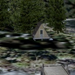
Mt Matlock Cabin
Sandspit (population: 460) lies on the northeast tip of Moresby Island, one of the Queen Charlotte Islands. The charming village lies on a spit of land extending into Hecate Strait. The Islands are blessed with a mild climate that has resulted in a rainforest of stunning, natural beauty, as well as lush vegetation and bountiful wildlife. Sandspit is home to the Islands’ main airport, with regular service available from Vancouver and Prince Rupert. A 25-minute ferry ride from Alliford Bay connects Sandspit to Skidegate Landing on Graham Island, the terminal for the 7-hour ferry to and from Prince Rupert.
Inhabited since prehistoric times, the Islands have been home to the Haida Nation for over 10,000 years. In 1993, the Canadian Government and the Council of the Haida Nation signed a landmark agreement to co-manage the newly protected Gwaii Haanas National Park Reserve and Haida Heritage Site on the southern half of Moresby Island. Sandspit is the major gateway for adventure travel into Gwaii Haanas, either by air or water.
A secluded cabin with small pier located on Sandspit Island. It's in a beautiful protected cove near Mt. Matlock.
WaveTop VFR Plan
From: Sandspit, BC
To: Mt. Matlock Cabin
-
NOTAM: Set Weather and Time from Misty's Place, also go to the Map Room to see a rough flight plan of this flight.
COURSE: We leave Sandspit, BC and set a heading of about 236. We are heading in the direction of Queen Charlotte City. We will first fly over Skidgate on the tip of Stony Point. This will pass by the starboard side of the aircraft.
-
Skidgate: The Haida community of Skidegate on the shores of Rooney Bay, known for years as Skidegate Mission, was a village site for many years, and became the location of the United Church Mission at the turn of the century. Skidegate is named after the chief of the village in the early 1800s, as was customary at the time. When Daniel Pender surveyed the waterway in 1866, he standardized the name for the inlet and channel from Skit-ei-get, meaning 'red paint stone', to Skidegate.
-
Skidegate is centrally located on the islands, situated as it is on the island highway and just a short ferry ride from Moresby Island and the airport at Sandspit. Outdoor recreation in the area includes - amongst other activities - fishing, boating, camping, beachcombing, hiking, kayaking, sightseeing, and wildlife viewing.
-
Documented as a thriving community by the first European explorers to the islands, Skidegate became a hub for early trade in otter furs. Today, Skidegate is one of two cultural centers of the Haida nation on the islands, and the site of a strong Haida cultural revival where the visitor can examine art and cultural artifacts first hand, and purchase beautiful Haida jewelry and crafts.
-
During the late 1800s, the Haida population in the traditional Haida villages declined dramatically as a result of smallpox epidemics and other European illnesses, against which the aboriginals had no immunity. The surviving Haida left their ancient villages and regrouped in communities in Skidegate Mission and Masset.
COURSE: Continue on your course as you pass Skidgate, your next point is a large island directly ahead about 4 miles.
-
Queen Charlotte City (population: 948) is located in Bearskin Bay on the southern shore of Graham Island. It is part of the archipelago known as the Queen Charlotte Islands, or Haida Gwaii. Sleeping Beauty Mountain rises up behind it. The town is the administrative center for the Queen Charlotte Islands and contains more shops and services than its small size would suggest. The moist, mild climate allows for lush vegetation and abundant wildlife. Most people visit to experience the natural beauty and the rich Haida culture that flourishes here, but there's lots more to explore in Queen Charlotte City.
In late summer, the alpine meadows are dotted with one of the many unique species of plants, the "Newcombe's Daisy." Trail maps are available at the BC Forest office. Fishing, kayaking, floatplane trips, beachcombing and diving are all spectacular. Whale watching is outstanding here.
COURSE: Over the large island, look for a tiny lake almost at the end of the island. Over that lake, make a sharp turn to starboard setting a course for the port side of Skowkona Mountain (about 1900 feet) at 335 degrees .. about 5 miles ahead.
COURSE: When the peak of Skowkona Mountain is at 3 o:clock, turn to a heading of 262 for 4 miles. You will fly over a ridge, maintain 1500 feet (Make sure your Barometer is set!) This will bring you over Yakoun Lake.
COURSE: Over Yakoun Lake, turn to a heading of 218, flying to the lake's western shore. You will see a shallow valley forming ahead and to starboard.
COURSE: Over the shoreline of the lake, turn to starboard to a heading of 250 ... you will follow this shallow valley.
-
NOTAM: there is a PEAK higher than your present altitude ahead, fly to the starboard side of that peak between it and Parish Mountain to your right. As you pass through this notch, you will see water ahead.
-
NOTAM: After the "notch" ... Turn the autopilot off and decend quickly toward the water ahead, assuming landing configuration. Slow down, full flaps, go down to 500 feet. You will go out over the water and turn sharply to port.
COURSE: As you approach the shoreline, you will notice there is an inlet to port. Fly up the starboard side of that inlet. Your landing zone is just beyond where it narrows. The cabin is straight ahead on the shore.
Welcome to Mt. Matlock Cabin!
Doug Linn
Charter Manager
Misty Moorings, Inc
contact@mistymoorings.com