
Destination:Lucky Lindy's Place
Route Notes
- This Scenery is for "Return to Misty Moorings" only.
- Minimum Altitude: 800 Feet
- Landing zone is: Dirt, Water, does not freeze
- GPS for Destination: N55 39.34 W131 21.19 Alt 27 Feet
- Print-Able copy HERE
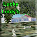
Lucky Lindy's Place
Not far from Ketchikan is a nice retreat for pilots and guests alike. There's a suitable dirt road for landing small bush planes here. All pilots MUST stop in and visit the office to leave your aircraft keys with the staff. We ask this because we know some pilots like to get a little too friendly with the lady's here and after having one too many cold one's, we make sure nobody gets in the cockpit unless they're in flying shape. There are adequate places to "Sleep it Off" here so if you get too "bubbly" just find a bunk and a bucket. We'll check on you to make sure you're still breathing. Our resort guests stay in rustic wood cabins and our resort transportation is provided from the office to the cabins by the "Old Gray Mare" A 1963 Gray "Blue Bird" bus. For the solitude and peace of our guests, we offer no phone or TV in the cabins. There is no smoking permitted inside Lindy's. The restaurant and bar are known for great trout and salmon meals. Our kitchen staff bring classic country cooking and local recipes for wonderful breakfast, lunches and dinners. Ask about our "Mad Scrambles" or try a lunch with homemade Chili and a big piece of Chocolate cake. Saturday night dinner is by reservation only and must be booked in advance. The resort is fully licensed. "Last Call" in the bar is normally around 11 PM or thereabouts Friday and Saturday nights. Friday night the grill is open with soups and sandwiches until 11pm. Come and have a drink by a warm fire.
WaveTop VFR Plan
FROM: Misty's Place (PF20)
TO: Lucky Lindy's Place
Notam: The Return to Misty Moorings Flight Plan calls for us to depart from PAKT, however today we are departing from Misty's Place.
COURSE: We will be taking off from Misty's Place. Taxi up near the little white house, turn around and take off down the runway at a heading of about 173. Once airborne, turn to port and fly over the little lighthouse ... watch out for the birds! Fly up the center of Boswick Inlet.
Course: As you leave Bostwick Inlet, turn to port over Bostwick Point to a heading of 23 heading for Walden Point (on the Annette Island or starboard side) 4.3 miles distant.
Blank inlet will come up to port, and beyond it you will be able to see Ketchikan International Airport (PAKT). Watch for traffic from starboard as you will be crossing under the approach for PAKT 29.
COURSE: As you cross Walden Point, look ahead for Mountain Point to Port, a point of land across the Tongass Narrows. Head for that point (heading about 35 degrees).
COURSE: At Mountain Point, set a heading of 11 degrees to fly up the south coast of Rivillagigedo Island (the island Ketchikan is on).
COURSE: The land mass in the center of the channel is the California Head. This splits the channel, George Inlet going to port and the Carroll Inlet to starboard. We are going to be going to starboard taking the Carroll Inlet up to Lucky Lindy's Place
COURSE: Over Mountain Point, set a heading of 33 degrees that will take you to the starboard side of the California Head. This routes you into the Carroll Inlet.
Watch for Herring Bay and the Herring Bay Cannery that will come up on your port side.
Just so you know, there have been some recent sightings of BigFoot in this area as reported in this clipping from Rob Alley's Book:
"
This year it has been difficult to get out to investigate reports, and I have no actual sightings or tracks to report.
However, the USFS did have one unusual case of damage to two of their trucks on an isolated logging road system east of Ketchikan in April 2000.
The road system was the Shelter Cove logging road system on the west side of Carroll Inlet. The trucks were separated by an air-distance of approximately 25 miles, but by an actual driving distance of over 100 miles.
Allegedly, one truck and one suburban were both found one morning, with windows smashed in and the roof of one of the vehicles compressed down with an estimated force of 1,000 lb.
There were no marks to indicate human involvement and vandalism was not the official explanation.
Officially, the report, which I have not been able to obtain, suggested that the work was that of a bear or bears. Only black bear occur on Revilla, and their weight is rarely in excess of 650 or 700 lb."
So we should "look around" first before stepping out of the plane at Lucky Lindy's!
COURSE: Continue to follow the Carroll Inlet. Soon the inlet will make a sharp S turn, first to port, then back to starboard.
After the S turn, you will pass over tiny Hume Island. And 2 miles further up the inlet you will fly over Osten Island. Island point then protrudes into the inlet on the port side. Continue to fly the center of the Carroll Inlet.
Just after Calamity Creek on the starboard side and little Shelter Cove on port, the inlet narrows.
As we fly, it is interesting to note that we are flying into Revillagigedo Island (the island Ketchikan is on). The island runs about 50 miles north-south and 35 miles east-west, it is 1,063.65 square miles in area, making it the 12th largest island in the United States and the 166th largest island in the world. The island is separated from the Alaska mainland to the east by Behm Canal, from Prince of Wales Island to the west by the Clarence Strait, and from Annette Island to the south. It was named by George Vancouver for Juan Vicente de Güemes, 2nd Count of Revillagigedo, then viceroy of Mexico, in 1793. The island's population was 13,950 as of the 2000 census. The only cities on the island are Ketchikan and Saxman. The principal industries are fishing, canning, logging and tourism. In addition to the stationary cities, there are several barge-based logging communities which move about. These serve the unconnected system of logging roads that dot the island.
COURSE: You are about 4 miles from landing. The landing zones for water and dirt are to the starboard side of the inlet. Prepare for landing. Lucky Lindy's is at the end of the inlet, land in the water ahead of it or on a very rough dirt strip to the right.
NOTAM: The dirt strip is a road. Look for four white signs that indicate the safest place to land. (Good luck!)
Welcome to Lucky Lindy's Place!
Doug Linn
Charter Manager
Misty Moorings, Inc
contact@mistymoorings.com