
Destination: Kitsault Gold Camp
Route Notes
- This Scenery is for Return to Misty Moorings only.
- Minimum Altitude: 1200 - 3600 at the landing zone.
- Landing zone is: Dirt
- GPS for destination: N55 24.18 W129 23.02 Alt 3179'
- Print-Able copy HERE
- Flight Seeing Plan available HERE
Kitsault Gold Camp
Immediately north of Kitsault Gold Camp lie the towering cliffs of granite and basalt formed from volcanic lava some seventy one million years ago. Formed during the Tertiary Period of geologic time it's a morass of gorges and mountain passes hard enough to claim many lives from those interested in what may lie beneath the surface. Far to the West lie the barrier mountain ranges that guard the Pacific Ocean approaches. To the East, the wilderness knows no boundary. Exploration for Gold began here shortly after the civil war in the United States as prospectors came and laid claim to plots up and down the territory with the Kitsault area. The land in this area has served as a natural barrier between the lower desert and the mountainous region of the Superstition Wilderness. Prospectors have dug shafts and tunnels all along the wilderness pathways searching for copper, gold and silver for the past seventy years.
The Kitsault Gold Camp sprung up from the need for expeditions to have supplies and the small area of land became a popular trading post with the local indigenous tribes during the late 19th century. As word of "Gold Fever" spread to the area, small groups of trappers, prospectors and settlers found their way into the territory to find new promises of riches. Some were able to make small fortunes but most never saw a substantial return and they left for other locations. The Camp is a throwback to the day's of the gold rush and visitors today can experience panning for gold in the nearby rivers and streams. A trading post supplies most of the gear for everyone to have a chance to strike it rich. You keep what you find and rumor has it that there's more gold and riches yet to be discovered.
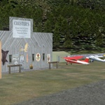
Chester Graves and his wife Gretchen, still operate tourist expeditions and each day, a group of guests will summon up the courage to take a horseback ride down to the nearby Kitsault River to pan for riches. Bear, Moose, Caribou and Wolf are all frequent visitors to the area and are spotted frequently. Afterwards, enjoy a great meal in "Chesters" Trading Post before departing back to the modern world.
WaveTop VFR Plan
From: Prince Rupert, BC (CYPR)
To: Kitsault Gold Camp
- NOTAM: Set Weather and Time from Misty's Place, also go to the Map Room to see a rough flight plan of this flight.
Overview: We will be flying from Prince Rupert to the Portland Inlet. We will then fly up the inlet for 20 miles until it splits into the Observation Inlet and Nass Bay. We will then travel another 20 miles up Observation Inlet. At the end, this also splits into the Hastings and Alice Arm. We will head toward the Alice arm but turn sharply into the mountains and follow a valley there until it ends. Then we will climb to 3700 feet and turn left to the landing zone.
COURSE: We will be leaving from Prince Rupert airport, CYPR. After liftoff, set a heading of 315. You will fly over Venn Pass with Duncan Bay passing to port. We will stay on this course for 20 miles.
- Along the way, Finlayson Island will come up on your port side and beyond that you will pass over Bernie Bay just to starboard and Bernie Island, a little farther ahead to port.
- When you reach the final point of land to starboard, a large channel will open up before you to starboard. This is the Portland Inlet and we are going to spend most of the rest of our trip flying up this wide channel of water.
COURSE: As you enter the mouth of the Portland Inlet, off shore of Truro Dials, about 2 o'clock to starboard. Let that course guide you to the center of the Portland Inlet. George Vancouver mapped the inlet in 1793 and named it "Brown Inlet," later changing the name to honor the British House of Portland.
- You will pass by Summerville Island to starboard. Coming up to port will be two tiny marker buoys just off Lizard Point. We will be going about 40 miles further on this inlet.
Background on the Kitsault Mining Project:
- Kitsault is one of the top five primary Molybdenum development assets worldwide. It is a high-grade resource with existing infrastructure consisting of an electricity grid and ocean and road access. It is permitted, but will need an amendment for tailings disposal and the resultant environmental assessment. An ongoing reclamation plan is already in place. Avanti will be able to benefit from the extensive historical geologic, production and other data compiled by others during Kitsault's prior two periods of production.
- While it is early in the re-evaluation of the three Molybdenum deposits, there are some initial ideas for additional exploration that might lead to expansion of the resources and the possible discovery of previously unknown Molybdenum deposits. An airborne geophysical survey is needed to define areas of interest outside of the known deposits.
- The actual location of the Kitsault Molybdenum mine is located 600 m above sea level, within a couple kilometers of tidewater on Alice Arm, in the Skeena Mining Division of British Columbia. It is 140 km northeast of Prince Rupert, British Columbia, and is easily accessible by air service or boat from Prince Rupert, or by road from the town of Terrace.
- The history of this mine goes back to 1911. At that time, the major focus was a polymetallic vein with silver values, located southeast of the Molybdenum deposit. Although some work was done on the project in the 1920s and early 1930s, the ground lay idle until 1959 when Kennco Exploration (Western) Ltd. commenced a program of diamond drilling. Kennco announced the presence of an orebody in late 1964, containing 36 million tonnes averaging 0.138% Mo (0.23% MoS2), and began construction of a mine at a capital cost of $30 million. Between January 1968 and April 1972, approximately 9.3 million tonnes of ore were produced with about 22.9 million pounds of Molybdenum recovered.
Some highlights about the Kitsault mining project:
- Kitsault is one of the top five primary Molybdenum development assets worldwide.
- It is a high-grade resource with existing infrastructure consisting of an electricity grid and ocean and road access.
- It is permitted, but will need an amendment for tailings disposal and the resultant environmental assessment.
- An ongoing reclamation plan is already in place.
- Avanti will be able to benefit from the extensive historical geologic, production and other data compiled by others during Kitsault's prior two periods of production.
- While it is early in the re-evaluation of the three Molybdenum deposits, there are some initial ideas for additional exploration that might lead to expansion of the resources and the possible discovery of previously unknown Molybdenum deposits. An airborne geophysical survey is needed to define areas of interest outside of the known deposits.
-
Production History: The deposit was first staked in 1911. At that time, the major focus was a polymetallic vein with silver values, located southeast of the Molybdenum deposit. Although some work was done on the project in the 1920s and early 1930s, the ground lay idle until 1959 when Kennco Exploration (Western) Ltd. commenced a program of diamond drilling. Kennco announced the presence of an orebody in late 1964, containing 36 million tonnes averaging 0.138% Mo (0.23% MoS2), and began construction of a mine at a capital cost of $30 million. Between January 1968 and April 1972, approximately 9.3 million tonnes of ore were produced with about 22.9 million pounds of Molybdenum recovered.
Geology
- The Kitsault property contains three known Molybdenum deposits: Kitsault, Bell Moly, and Roundy Creek, all of which are within the western margin of the Bowser basin in the Intermountain tectonic belt, a few kilometers east of the Coast Plutonic Complex. Hosts for mineralization of these three deposits are thermally metamorphosed interbedded argillite and greywacke of the Upper Jurassic to Lower Cretaceous Bowser Lake Group, and the intrusive lithologies of the Lime Creek Intrusive Complex, Clary Creek Stock, and Roundy Creek instrusive complex, respectively. Intrusives associated with Molybdenum mineralization at Kitsault, Bell Moly, and Roundy Creek are multiphase diorite, quartz monzonite, and younger felsic units. Cross cutting relationships within the intrusive indicate that multiple mineralizing events produced the Molybdenum deposits.
COURSE: As Gwent Bay comes up to Starboard with Ramsden Point ahead about 6 miles, look toward the end of the point to port and you should see Gwent Bay Cannery as we pass by.
COURSE: Ahead the Inlet forms a Y intersection. You will go to about 11 o'clock up Observation Inlet, passing by the waterway going off to starboard at 2 o'clock which is Nass Bay. The Nass river flows into this about 6 miles to starboard.
COURSE: As you enter Observation Inlet, you have 29 miles of easy flying ahead of you until we make our turn back into the Kitsault area. Just continue to follow the course of the waterway.
COURSE: At a seemingly last point of land to port (where the Observation Inlet spreads out considerably, look ahead and you will see it ends in about 8 miles ahead splitting into the Hastings Arm going 11 o'clock to port and the Alice Arm going about 2 o'clock to starboard. We will be turning into the Alice Arm.
COURSE: Watch for Brook Island, on this heading it should pass just to starboard, it is a long, narrow island.
COURSE: As you enter the Alice Arm, there is a small island in the center of this entrance. Fly over that small island.
COURSE: Look to starboard and you will see a gap between the mountains about 2 o'clock. You will be turning into that gap and flying up a river you will find there between the mountains. Your heading will roughly be an average of 98 degrees. Follow the river and the valley.
NOTAM: This valley rises from sea level to about 3500 feet. You can follow it low and slow until almost the end, but will have to climb fast to 3600 feet. You can reset your autopilot altitude for 3600 feet.
COURSE: When the river ends, be at an altitude of 3600 feet and turn around the mountain to port to a heading of 15 degrees.
NOTAM: Turn OFF THE AUTOPILOT. Assume landing configuration for a dirt strip. Your landing zone is 3.3 miles ahead.
COURSE: Watch for a narrow lake, fly over it, your landing strip is just beyond it about 1 o'clock.
Welcome to Kitsault Gold camp.
Doug Linn
Charter Manager
Misty Moorings, Inc
contact@mistymoorings.com